Weather Alert in Washington
Red Flag Warning issued August 27 at 1:09AM PDT until August 27 at 8:00PM PDT by NWS Seattle WA
AREAS AFFECTED: West Slopes of the North Cascades Generally above 1500 Feet; West Slopes of the Central Cascades Generally above 1500 Feet; East Portion of the Olympic Mountains
DESCRIPTION: The National Weather Service in Seattle has issued a Red Flag Warning for dry thunderstorms and gusty outflow winds, which is in effect from 11 AM this morning to 8 PM PDT this evening. * AFFECTED AREA...Fire Weather Zone 658 West Slopes of the North Cascades Generally above 1500 Feet, Fire Weather Zone 659 West Slopes of the Central Cascades Generally above 1500 Feet and Fire Weather Zone 661 East Portion of the Olympic Mountains. * THUNDERSTORMS...Thunderstorms are favored along the eastern slopes of the Olympic mountains between 11 AM and 3 PM, and more so in the Cascades from 3 PM to 8 PM. Wetting rains are possible, but lightning strikes on very dry fuel are capable of new fire starts. * OUTFLOW WINDS...Outflow winds of 25 to 30 mph are possible. Outflow winds can occur ahead of and behind storms and cause erratic wind directions. * IMPACTS...Scattered lightning in dry fuels can cause multiple fire starts. Thunderstorms can also bring sudden sharp wind shifts on existing fires, causing rapid changes in a fire's rate of spread and direction of spread. Thunderstorm outflow winds can be a threat for several hours following the start of a new lightning-caused fire. If a fire were to begin, air quality may diminish in the surrounding area.
INSTRUCTION: A Red Flag Warning means that critical fire weather conditions are either imminent or occurring now. Any fires that develop will likely spread quickly. Outdoor burning is not recommended.
Want more detail? Get the Complete 7 Day and Night Detailed Forecast!
Current U.S. National Radar--Current
The Current National Weather Radar is shown below with a UTC Time (subtract 5 hours from UTC to get Eastern Time).

National Weather Forecast--Current
The Current National Weather Forecast and National Weather Map are shown below.

National Weather Forecast for Tomorrow
Tomorrow National Weather Forecast and Tomorrow National Weather Map are show below.

North America Water Vapor (Moisture)
This map shows recent moisture content over North America. Bright and colored areas show high moisture (ie, clouds); brown indicates very little moisture present; black indicates no moisture.

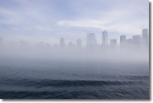
Weather Topic: What is Fog?
Home - Education - Cloud Types - Fog
 Next Topic: Fractus Clouds
Fog is technically a type of stratus cloud, which lies along the
ground and obscures visibility.
It is usually created when humidity in the air condenses into tiny water droplets.
Because of this, some places are more prone to foggy weather, such as regions
close to a body of water.
Fog is similar to mist; both are the appearance of water droplets suspended in
the air, but fog is the term applied to the condition when visibility is less than 1 km.
Next Topic: Fractus Clouds
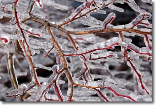
Weather Topic: What is Freezing Rain?
Home - Education - Precipitation - Freezing Rain
 Next Topic: Graupel
Freezing rain is a condition where precipitation which has fallen in the form of
water droplets reaches temperatures which are below freezing and freezes upon
coming into contact
with surface objects. The result of this precipitation is a glaze of ice which
can be damaging to plants and man-made structures. A severe onset of freezing
rain which results in a very thick glaze of ice is known as an ice storm.
Next Topic: Graupel
Current conditions powered by WeatherAPI.com


