Weather Alert in Washington
Red Flag Warning issued August 27 at 1:09AM PDT until August 27 at 8:00PM PDT by NWS Seattle WA
AREAS AFFECTED: West Slopes of the North Cascades Generally above 1500 Feet; West Slopes of the Central Cascades Generally above 1500 Feet; East Portion of the Olympic Mountains
DESCRIPTION: The National Weather Service in Seattle has issued a Red Flag Warning for dry thunderstorms and gusty outflow winds, which is in effect from 11 AM this morning to 8 PM PDT this evening. * AFFECTED AREA...Fire Weather Zone 658 West Slopes of the North Cascades Generally above 1500 Feet, Fire Weather Zone 659 West Slopes of the Central Cascades Generally above 1500 Feet and Fire Weather Zone 661 East Portion of the Olympic Mountains. * THUNDERSTORMS...Thunderstorms are favored along the eastern slopes of the Olympic mountains between 11 AM and 3 PM, and more so in the Cascades from 3 PM to 8 PM. Wetting rains are possible, but lightning strikes on very dry fuel are capable of new fire starts. * OUTFLOW WINDS...Outflow winds of 25 to 30 mph are possible. Outflow winds can occur ahead of and behind storms and cause erratic wind directions. * IMPACTS...Scattered lightning in dry fuels can cause multiple fire starts. Thunderstorms can also bring sudden sharp wind shifts on existing fires, causing rapid changes in a fire's rate of spread and direction of spread. Thunderstorm outflow winds can be a threat for several hours following the start of a new lightning-caused fire. If a fire were to begin, air quality may diminish in the surrounding area.
INSTRUCTION: A Red Flag Warning means that critical fire weather conditions are either imminent or occurring now. Any fires that develop will likely spread quickly. Outdoor burning is not recommended.
Want more detail? Get the Complete 7 Day and Night Detailed Forecast!
Current U.S. National Radar--Current
The Current National Weather Radar is shown below with a UTC Time (subtract 5 hours from UTC to get Eastern Time).

National Weather Forecast--Current
The Current National Weather Forecast and National Weather Map are shown below.

National Weather Forecast for Tomorrow
Tomorrow National Weather Forecast and Tomorrow National Weather Map are show below.

North America Water Vapor (Moisture)
This map shows recent moisture content over North America. Bright and colored areas show high moisture (ie, clouds); brown indicates very little moisture present; black indicates no moisture.

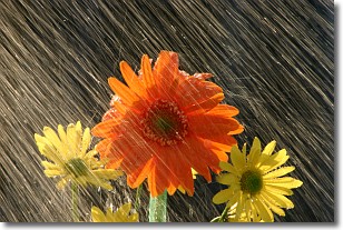
Weather Topic: What is Rain?
Home - Education - Precipitation - Rain
 Next Topic: Shelf Clouds
Precipitation in the form of water droplets is called rain.
Rain generally has a tendency to fall with less intensity over a greater period
of time, and when rainfall is more severe it is usually less sustained.
Rain is the most common form of precipitation and happens with greater frequency
depending on the season and regional influences. Cities have been shown to have
an observable effect on rainfall, due to an effect called the urban heat island.
Compared to upwind, monthly rainfall between twenty and forty miles downwind of
cities is 30% greater.
Next Topic: Shelf Clouds
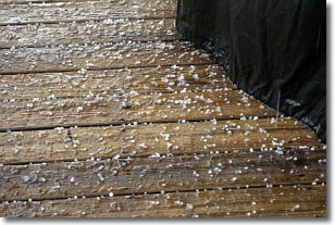
Weather Topic: What is Sleet?
Home - Education - Precipitation - Sleet
 Next Topic: Snow
Sleet is a form of precipitation in which small ice pellets are the primary
components. These ice pellets are smaller and more translucent than hailstones,
and harder than graupel. Sleet is caused by specific atmospheric conditions and
therefore typically doesn't last for extended periods of time.
The condition which leads to sleet formation requires a warmer body of air to be
wedged in between two sub-freezing bodies of air. When snow falls through a warmer
layer of air it melts, and as it falls through the next sub-freezing body of air
it freezes again, forming ice pellets known as sleet. In some cases, water
droplets don't have time to freeze before reaching the surface and the result is
freezing rain.
Next Topic: Snow
Current conditions powered by WeatherAPI.com


