Weather Alert in Alaska
Flood Warning issued August 26 at 10:30PM AKDT until August 27 at 11:00PM AKDT by NWS Fairbanks AK
AREAS AFFECTED: Central Brooks Range; South Slopes Of The Central Brooks Range; Upper Koyukuk Valley; Dalton Highway Summits
DESCRIPTION: * WHAT...Flooding caused by excessive rainfall continues. * WHERE...Including the following areas, Central Brooks Range, Dalton Highway Summits, South Slopes Of The Central Brooks Range and Upper Koyukuk Valley. * WHEN...Until 1100 PM AKDT Wednesday. * IMPACTS...Flooding of rivers, creeks, streams, and other low-lying and flood-prone locations is imminent or occurring. * ADDITIONAL DETAILS... - At 1018 PM AKDT, River gauge reports indicate rises in water levels from heavy rain across the warned area. Flooding is ongoing. Between 4 and 6 inches of rain have fallen. Additional rainfall amounts of up to an inch are possible. - There is controlled traffic along the Dalton Highway between mile markers 140 and 240 due to road damage from flooding earlier today. Numerous landslides have also been reported by the public near Wiseman along steep slopes in the area. - For Slate Creek at Coldfoot: At 10:23pm the stage was 18.9 feet and receding. Flood Stage is 18.7 feet. - Http://www.weather.gov/aprfc
INSTRUCTION: Stay tuned to further developments by listening to your local radio, television, or NOAA Weather Radio for further information.
Want more detail? Get the Complete 7 Day and Night Detailed Forecast!
Current U.S. National Radar--Current
The Current National Weather Radar is shown below with a UTC Time (subtract 5 hours from UTC to get Eastern Time).

National Weather Forecast--Current
The Current National Weather Forecast and National Weather Map are shown below.

National Weather Forecast for Tomorrow
Tomorrow National Weather Forecast and Tomorrow National Weather Map are show below.

North America Water Vapor (Moisture)
This map shows recent moisture content over North America. Bright and colored areas show high moisture (ie, clouds); brown indicates very little moisture present; black indicates no moisture.

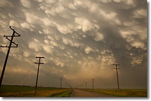
Weather Topic: What are Mammatus Clouds?
Home - Education - Cloud Types - Mammatus Clouds
 Next Topic: Nimbostratus Clouds
A mammatus cloud is a cloud with a unique feature which resembles
a web of pouches hanging along the base of the cloud.
In the United States, mammatus clouds tend to form in the warmer months, commonly
in the Midwest and eastern regions.
While they usually form at the bottom of a cumulonimbis cloud, they can also form
under altostratus, altocumulus, stratocumulus, and cirrus clouds. Mammatus clouds
warn that severe weather is close.
Next Topic: Nimbostratus Clouds
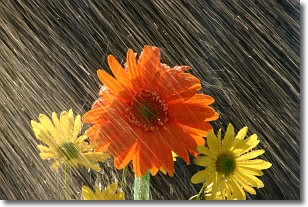
Weather Topic: What is Precipitation?
Home - Education - Precipitation - Precipitation
 Next Topic: Rain
Precipitation can refer to many different forms of water that
may fall from clouds. Precipitation occurs after a cloud has become saturated to
the point where its water particles are more dense than the air below the cloud.
In most cases, precipitation will reach the ground, but it is not uncommon for
precipitation to evaporate before it reaches the earth's surface.
When precipitation evaporates before it contacts the ground it is called Virga.
Graupel, hail, sleet, rain, drizzle, and snow are forms of precipitation, but fog
and mist are not considered precipitation because the water vapor which
constitutes them isn't dense enough to fall to the ground.
Next Topic: Rain
Current conditions powered by WeatherAPI.com


