Weather Alert in Montana
Winter Storm Watch issued March 31 at 12:51PM MDT until April 3 at 12:00PM MDT by NWS Great Falls MT
AREAS AFFECTED: Cascade County below 5000ft; Judith Basin County and Judith Gap; Fergus County below 4500ft; Little Belt and Highwood Mountains; Snowy and Judith Mountains; Big Belt, Bridger and Castle Mountains; Gallatin and Madison County Mountains and Centennial Mountains
DESCRIPTION: * WHAT...Heavy, wet snow possible. Total snow accumulations between 4 and 8 inches possible at elevations below 5,000 feet and 8 to 16 inches possible above 5,000 feet. Winds could gust as high as 40 mph. * WHERE...Portions of central, north central, and southwest Montana. * WHEN...From Thursday afternoon through Friday morning. * IMPACTS...Slushy snow covered roads and significantly reduced visibility at times may make travel very difficult. The hazardous conditions could impact the Thursday evening and Friday morning commutes. Those in the backcountry should ensure they are prepared for dangerous conditions. * ADDITIONAL DETAILS...The combination of heavy, wet snow and winds may cause power outages and tree damage.
INSTRUCTION: Monitor the latest forecasts for updates on this situation. To see a graphical representation of the degree of stress on young livestock please visit our webpage and select Local Programs then Cold Air Advisory for Newborn Livestock.
Want more detail? Get the Complete 7 Day and Night Detailed Forecast!
Current U.S. National Radar--Current
The Current National Weather Radar is shown below with a UTC Time (subtract 5 hours from UTC to get Eastern Time).

National Weather Forecast--Current
The Current National Weather Forecast and National Weather Map are shown below.

National Weather Forecast for Tomorrow
Tomorrow National Weather Forecast and Tomorrow National Weather Map are show below.

North America Water Vapor (Moisture)
This map shows recent moisture content over North America. Bright and colored areas show high moisture (ie, clouds); brown indicates very little moisture present; black indicates no moisture.

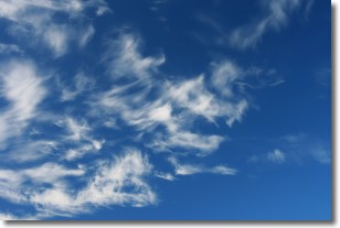
Weather Topic: What are Cirrostratus Clouds?
Home - Education - Cloud Types - Cirrostratus Clouds
 Next Topic: Cirrus Clouds
Cirrostratus clouds are high, thin clouds that form above
20,000 feet and are made mostly of ice crystals. They sometimes look like giant
feathers, horse tails, or curls of hair in the sky.
These clouds are pushed by the jet stream and can move at high speeds reaching
100 mph.
What do they indicate?
They indicate that a precipitation is likely within 24 hours.
Next Topic: Cirrus Clouds
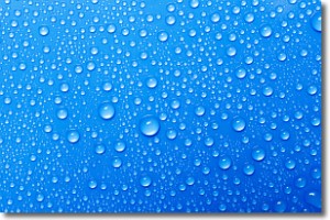
Weather Topic: What is Condensation?
Home - Education - Precipitation - Condensation
 Next Topic: Contrails
Condensation is the process which creates clouds, and therefore
it is a crucial process in the water cycle.
Condensation is the change of matter from a state of gas into a state of liquid,
and it happens because water molecules release heat into the atmosphere and
become organized into a more closely packed structure, what we might see as
water droplets.
Water is always present in the air around us as a vapor, but it's too small for
us to see. When water undergoes the process of condensation it becomes organized
into visible water droplets. You've probably seen condensation happen before on the
surface of a cold drink!
Next Topic: Contrails
Current conditions powered by WeatherAPI.com


