Weather Alert in Montana
High Wind Warning issued March 7 at 11:34AM MST until March 8 at 11:00PM MST by NWS Great Falls MT
AREAS AFFECTED: Big Belt, Bridger and Castle Mountains; Meagher County Valleys; Elkhorn and Boulder Mountains; Canyon Ferry Area; Missouri Headwaters
DESCRIPTION: * WHAT...Southwest winds 30 to 40 mph with gusts up to 65 mph expected, particularly in the wind prone areas. * WHERE...Big Belt, Bridger and Castle Mountains, Canyon Ferry Area, Elkhorn and Boulder Mountains, Meagher County Valleys, and Missouri Headwaters. * WHEN...From 3 AM Sunday to midnight MDT Sunday Night. * IMPACTS...High winds may move loose debris, damage property and cause power outages. Travel could be difficult, especially for high profile vehicles. Localized blowing dust and snow will be possible.
INSTRUCTION: People are urged to secure loose objects that could be blown around or damaged by the wind. Remember, a High Wind Warning means that there is at least an 80% chance of 40 mph sustained winds or 58 mph wind gusts occurring during the warning period.
Want more detail? Get the Complete 7 Day and Night Detailed Forecast!
Current U.S. National Radar--Current
The Current National Weather Radar is shown below with a UTC Time (subtract 5 hours from UTC to get Eastern Time).

National Weather Forecast--Current
The Current National Weather Forecast and National Weather Map are shown below.

National Weather Forecast for Tomorrow
Tomorrow National Weather Forecast and Tomorrow National Weather Map are show below.

North America Water Vapor (Moisture)
This map shows recent moisture content over North America. Bright and colored areas show high moisture (ie, clouds); brown indicates very little moisture present; black indicates no moisture.

Weather Topic: What are Cumulonimbus Clouds?
Home - Education - Cloud Types - Cumulonimbus Clouds
 Next Topic: Cumulus Clouds
The final form taken by a growing cumulus cloud is the
cumulonimbus cloud, which is very tall and dense.
The tower of a cumulonimbus cloud can soar 23 km into the atmosphere, although
most commonly they stop growing at an altitude of 6 km.
Even small cumulonimbus clouds appear very large in comparison to other cloud types.
They can signal the approach of stormy weather, such as thunderstorms or blizzards.
Next Topic: Cumulus Clouds
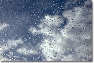
Weather Topic: What is Drizzle?
Home - Education - Precipitation - Drizzle
 Next Topic: Evaporation
Drizzle is precipitation in the form of water droplets which are
smaller than raindrops.
Drizzle is characterized by fine, gently falling droplets and typically does not
impact human habitation in a negative way. The exception to this is freezing drizzle,
a condition where drizzle freezes immediately upon reaching earth's surface.
Freezing drizzle is still less dangerous than freezing rain, but can
potentially result in hazardous road conditions.
Next Topic: Evaporation
Current conditions powered by WeatherAPI.com


