Weather Alert in Utah
Avalanche Watch issued February 16 at 5:15AM MST by NWS Salt Lake City UT
AREAS AFFECTED: Wasatch Mountains I-80 North; Wasatch Mountains South of I-80; Western Uinta Mountains; Wasatch Plateau/Book Cliffs; Central Mountains; Southern Mountains
DESCRIPTION: AVASLC * WHAT...Heavy snowfall and strong winds are expected to rapidly increase avalanche danger across northern and central Utah beginning tomorrow morning and continuing through the week. Forecasters at the Utah Avalanche Center expect dangerous and complex avalanche conditions to develop on many slopes, with natural and human-triggered avalanches likely. * WHERE...For the mountains of Northern, Central, and Southwestern Utah as well as Southeastern Idaho, including...the Wasatch Range...Bear River Range...Western Uinta Mountains...Wasatch Plateau...Tushars. * WHEN...The Watch will be in effect 6AM Monday through 6AM Tuesday, though increased avalanche danger is expected to continue through the week. * IMPACTS...Dangerous avalanche conditions are expected to develop on many slopes. Avalanches can be triggered on slopes steeper than 30 degrees. They may also be triggered remotely (from a distance) or from below. * ADDITIONAL DETAILS...What to do...Avoid traveling on or underneath steep terrain at mid and upper elevations in the backcountry. Carry and know how to use avalanche rescue equipment, including a transceiver, shovel, and probe. Find safer riding conditions on slopes less than 30 degrees with no overhead hazard.
INSTRUCTION: Stay off of and out from under slopes steeper than 30 degrees. Backcountry travelers should consult www.utahavalanchecenter.org or call 1-888-999-4019 for more detailed information. This Watch does not apply to ski areas where avalanche hazard reduction measures are performed.
Want more detail? Get the Complete 7 Day and Night Detailed Forecast!
Current U.S. National Radar--Current
The Current National Weather Radar is shown below with a UTC Time (subtract 5 hours from UTC to get Eastern Time).

National Weather Forecast--Current
The Current National Weather Forecast and National Weather Map are shown below.

National Weather Forecast for Tomorrow
Tomorrow National Weather Forecast and Tomorrow National Weather Map are show below.

North America Water Vapor (Moisture)
This map shows recent moisture content over North America. Bright and colored areas show high moisture (ie, clouds); brown indicates very little moisture present; black indicates no moisture.

Weather Topic: What are Contrails?
Home - Education - Cloud Types - Contrails
 Next Topic: Cumulonimbus Clouds
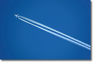
A contrail is an artificial cloud, created by the passing of an
aircraft.
Contrails form because water vapor in the exhaust of aircraft engines is suspended
in the air under certain temperatures and humidity conditions. These contrails
are called exhaust contrails.
Another type of contrail can form due to a temporary reduction in air pressure
moving over the plane's surface, causing condensation.
These are called aerodynamic contrails.
When you can see your breath on a cold day, it is also because of condensation.
The reason contrails last longer than the condensation from your breath is
because the water in contrails freezes into ice particles.
Next Topic: Cumulonimbus Clouds
Weather Topic: What are Cumulus Clouds?
Home - Education - Cloud Types - Cumulus Clouds
 Next Topic: Drizzle
Cumulus clouds are fluffy and textured with rounded tops, and
may have flat bottoms. The border of a cumulus cloud
is clearly defined, and can have the appearance of cotton or cauliflower.
Cumulus clouds form at low altitudes (rarely above 2 km) but can grow very tall,
becoming cumulus congestus and possibly the even taller cumulonimbus clouds.
When cumulus clouds become taller, they have a greater chance of producing precipitation.
Next Topic: Drizzle
Current conditions powered by WeatherAPI.com


