Weather Alert in California
Winter Storm Warning issued February 14 at 1:08PM PST until February 18 at 4:00AM PST by NWS Medford OR
AREAS AFFECTED: Western Siskiyou County
DESCRIPTION: * WHAT...Heavy snow expected above 5000 ft through Monday morning with accumulations of 8 to 12 inches expected. After a brief lull in precipitation Monday afternoon, snow levels drop to around 2000 ft Monday night into Tuesday, remaining low through Thursday. Additional snow accumulations 6 to 12 inches are expected with 1 to 2 ft expected above 5000 ft. Winds gusting as high as 40 mph over high and exposed terrain. * WHERE...In western Siskiyou County, elevations above 5000 ft through Monday morning, lowering to 3000 ft Monday evening. This includes Etna Summit on Sawyers Bar Rd and Highway 3 south of Callahan. * WHEN...From 10 AM Sunday to 4 AM PST Wednesday. * IMPACTS...Travel may be very difficult to impossible. The hazardous conditions could impact the Monday morning and evening commutes. * ADDITIONAL DETAILS...Snow levels of 5000 feet on Sunday into Sunday evening are expected to lower to 4500 ft Sunday night then down to 4000 ft Monday. Snow levels lower further Monday night into Tuesday, possibly as low as 1500 ft by Tuesday morning. This could result in light snow accumulations of 1 to 3 inches in the Scott and Klamath River Valleys during Tuesday through Tuesday night. Visit weather.gov/mfr/winter for snow probabilities
INSTRUCTION: If you must travel, keep an extra flashlight, food, and water in your vehicle in case of an emergency. Call 511 or visit quickmap.dot.ca.gov for road information.
Want more detail? Get the Complete 7 Day and Night Detailed Forecast!
Current U.S. National Radar--Current
The Current National Weather Radar is shown below with a UTC Time (subtract 5 hours from UTC to get Eastern Time).

National Weather Forecast--Current
The Current National Weather Forecast and National Weather Map are shown below.

National Weather Forecast for Tomorrow
Tomorrow National Weather Forecast and Tomorrow National Weather Map are show below.

North America Water Vapor (Moisture)
This map shows recent moisture content over North America. Bright and colored areas show high moisture (ie, clouds); brown indicates very little moisture present; black indicates no moisture.

Weather Topic: What is Freezing Rain?
Home - Education - Precipitation - Freezing Rain
 Next Topic: Graupel
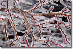
Freezing rain is a condition where precipitation which has fallen in the form of
water droplets reaches temperatures which are below freezing and freezes upon
coming into contact
with surface objects. The result of this precipitation is a glaze of ice which
can be damaging to plants and man-made structures. A severe onset of freezing
rain which results in a very thick glaze of ice is known as an ice storm.
Next Topic: Graupel
Weather Topic: What is Hail?
Home - Education - Precipitation - Hail
 Next Topic: Hole Punch Clouds
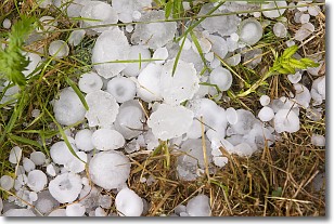
Hail is a form of precipitation which is recognized by large solid balls or
clumps of ice. Hail is created by thunderstorm clouds with strong updrafts of wind.
As the hailstones remain in the updraft, ice is deposited onto them until their
weight becomes heavy enough for them to fall to the earth's surface.
Hail storms can cause significant damage to crops, aircrafts, and man-made structures,
despite the fact that the duration is usually less than ten minutes.
Next Topic: Hole Punch Clouds
Current conditions powered by WeatherAPI.com


