Weather Alert in Hawaii
Flood Advisory issued February 8 at 8:47PM HST until February 9 at 12:00AM HST by NWS Honolulu HI
AREAS AFFECTED: Hawaii in Hawaii, HI
DESCRIPTION: * WHAT...Flooding caused by excessive rainfall continues. * WHERE...The island of Hawaii in Hawaii County. * WHEN...Until midnight HST tonight. * IMPACTS...Minor flooding on roads, poor drainage areas, and in streams. Some low-water crossings may become impassable. * ADDITIONAL DETAILS... - At 843 PM HST, radar indicated heavy rain over portions of the coastal and upslope areas of the Hamakua and Hilo districts. The heaviest rain was falling at a rate of 1 to 2 inches per hour, mainly between Hawi and Laupahoehoe, particularly over the Pu'u O Umi Natural Area Reserve. This could result in flooding in stream channels and along portions of Highway 19. - Some locations that will experience flooding include... Kapaau, Honokaa, Paauilo, Kukuihaele, Waipio Valley, Kamuela, Waimanu Valley, Ookala, Laupahoehoe, Pololu Valley, Ninole, Kohala Ranch, Halaula, Hakalau, Honomu, Hawi, Pepeekeo, Papaikou, Mahukona and Paukaa.
INSTRUCTION: Stay away from streams, drainage ditches and low lying areas prone to flooding. A statewide Flood Watch is also in effect until Monday 6 PM HST.
Want more detail? Get the Complete 7 Day and Night Detailed Forecast!
Current U.S. National Radar--Current
The Current National Weather Radar is shown below with a UTC Time (subtract 5 hours from UTC to get Eastern Time).

National Weather Forecast--Current
The Current National Weather Forecast and National Weather Map are shown below.

National Weather Forecast for Tomorrow
Tomorrow National Weather Forecast and Tomorrow National Weather Map are show below.

North America Water Vapor (Moisture)
This map shows recent moisture content over North America. Bright and colored areas show high moisture (ie, clouds); brown indicates very little moisture present; black indicates no moisture.

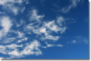
Weather Topic: What are Cirrostratus Clouds?
Home - Education - Cloud Types - Cirrostratus Clouds
 Next Topic: Cirrus Clouds
Cirrostratus clouds are high, thin clouds that form above
20,000 feet and are made mostly of ice crystals. They sometimes look like giant
feathers, horse tails, or curls of hair in the sky.
These clouds are pushed by the jet stream and can move at high speeds reaching
100 mph.
What do they indicate?
They indicate that a precipitation is likely within 24 hours.
Next Topic: Cirrus Clouds
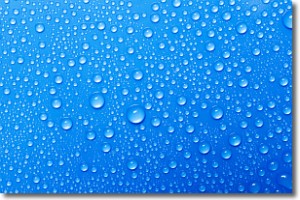
Weather Topic: What is Condensation?
Home - Education - Precipitation - Condensation
 Next Topic: Contrails
Condensation is the process which creates clouds, and therefore
it is a crucial process in the water cycle.
Condensation is the change of matter from a state of gas into a state of liquid,
and it happens because water molecules release heat into the atmosphere and
become organized into a more closely packed structure, what we might see as
water droplets.
Water is always present in the air around us as a vapor, but it's too small for
us to see. When water undergoes the process of condensation it becomes organized
into visible water droplets. You've probably seen condensation happen before on the
surface of a cold drink!
Next Topic: Contrails
Current conditions powered by WeatherAPI.com


