Weather Alert in New Mexico
Flash Flood Warning issued August 26 at 7:08PM MDT until August 26 at 8:45PM MDT by NWS Albuquerque NM
AREAS AFFECTED: Mora, NM
DESCRIPTION: At 708 PM MDT, trained weather spotters reported flash flooding along New Mexico State Highway 518 between Cleveland and Holman within the Hermits Peak Calf Canyon Burn Scar. Between 0.75 and 2.5 inches of rain have fallen. Additional rainfall amounts up to 1 inch are possible in the warned area. Flash flooding is already occurring. Excessive rainfall over the burn scar will impact the drainage areas for the tributaries of the Mora River, including Coyote Creek, Sierra Ditch, Canoncito Creek, Encinal Creek, and Rio La Casa. HAZARD...Life threatening flash flooding. Thunderstorms producing flash flooding in and around the Hermits Peak Calf Canyon Burn Scar. SOURCE...Trained spotters reported. IMPACT...Life threatening flash flooding of areas in and around the Hermits Peak Calf Canyon Burn Scar. Some locations that will experience flash flooding include... Mora, Cleveland, Holman, Ledoux, Morphy Lake State Park, La Cueva, Chacon, Gascon, Monte Aplanado and South Carmen.
INSTRUCTION: This is a life threatening situation. Heavy rainfall will cause extensive and severe flash flooding of creeks, streams and ditches in the Hermits Peak Calf Canyon Burn Scar. Severe debris flows can also be anticipated across roads. Roads and driveways may be washed away in places. If you encounter flood waters, climb to safety.
Want more detail? Get the Complete 7 Day and Night Detailed Forecast!
Current U.S. National Radar--Current
The Current National Weather Radar is shown below with a UTC Time (subtract 5 hours from UTC to get Eastern Time).

National Weather Forecast--Current
The Current National Weather Forecast and National Weather Map are shown below.

National Weather Forecast for Tomorrow
Tomorrow National Weather Forecast and Tomorrow National Weather Map are show below.

North America Water Vapor (Moisture)
This map shows recent moisture content over North America. Bright and colored areas show high moisture (ie, clouds); brown indicates very little moisture present; black indicates no moisture.

Weather Topic: What is Hail?
Home - Education - Precipitation - Hail
 Next Topic: Hole Punch Clouds
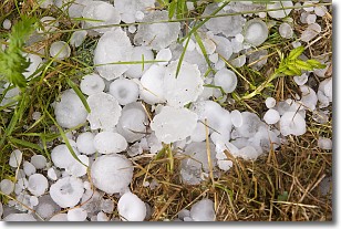
Hail is a form of precipitation which is recognized by large solid balls or
clumps of ice. Hail is created by thunderstorm clouds with strong updrafts of wind.
As the hailstones remain in the updraft, ice is deposited onto them until their
weight becomes heavy enough for them to fall to the earth's surface.
Hail storms can cause significant damage to crops, aircrafts, and man-made structures,
despite the fact that the duration is usually less than ten minutes.
Next Topic: Hole Punch Clouds
Weather Topic: What are Mammatus Clouds?
Home - Education - Cloud Types - Mammatus Clouds
 Next Topic: Nimbostratus Clouds
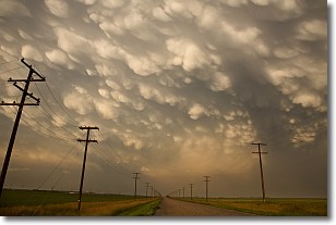
A mammatus cloud is a cloud with a unique feature which resembles
a web of pouches hanging along the base of the cloud.
In the United States, mammatus clouds tend to form in the warmer months, commonly
in the Midwest and eastern regions.
While they usually form at the bottom of a cumulonimbis cloud, they can also form
under altostratus, altocumulus, stratocumulus, and cirrus clouds. Mammatus clouds
warn that severe weather is close.
Next Topic: Nimbostratus Clouds
Current conditions powered by WeatherAPI.com


