Weather Alert in Minnesota
Winter Weather Advisory issued March 7 at 3:05AM CST until March 7 at 9:00AM CST by NWS Twin Cities/Chanhassen MN
AREAS AFFECTED: Mille Lacs; Kanabec; Sherburne; Isanti; Wright; McLeod; Sibley; Brown; Nicollet; Watonwan; Blue Earth; Martin; Faribault
DESCRIPTION: ...WINTRY PRECIPITATION, MAINLY AS LIGHT SNOW BUT POSSIBLY MIXED WITH FREEZING RAIN, WILL CONTINUE SHIFTING EAST OVER SOUTHERN AND EASTERN MINNESOTA THROUGH SUNRISE... .The overall swath of wintry precipitation, mainly as light snow, continues to shift east across central through southern Minnesota early this morning. The precipitation will continue through sunrise for southern and eastern Minnesota, producing a few tenths of an inch of snow and possibly a glazing of ice. Slick travel conditions are resulting from this wintry precipitation, and will persist through the rest of the overnight hours within the Advisory area. * WHAT...Freezing rain and snow expected. Additional snow accumulations of a few tenths of an inch and possibly a glazing of ice. * WHERE...McLeod, Sherburne, Sibley, Wright, Isanti, Kanabec, Mille Lacs, Blue Earth, Brown, Faribault, Martin, Nicollet, and Watonwan Counties. * WHEN...Until 9 AM CST this morning. * IMPACTS...Roads, and especially bridges and overpasses, will likely become slick and hazardous. Plan on slippery road conditions.
INSTRUCTION: Slow down and use caution while traveling. Call 5 1 1 or visit 511mn.org for road conditions.
Want more detail? Get the Complete 7 Day and Night Detailed Forecast!
Current U.S. National Radar--Current
The Current National Weather Radar is shown below with a UTC Time (subtract 5 hours from UTC to get Eastern Time).

National Weather Forecast--Current
The Current National Weather Forecast and National Weather Map are shown below.

National Weather Forecast for Tomorrow
Tomorrow National Weather Forecast and Tomorrow National Weather Map are show below.

North America Water Vapor (Moisture)
This map shows recent moisture content over North America. Bright and colored areas show high moisture (ie, clouds); brown indicates very little moisture present; black indicates no moisture.

Weather Topic: What is Hail?
Home - Education - Precipitation - Hail
 Next Topic: Hole Punch Clouds
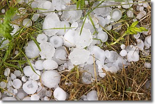
Hail is a form of precipitation which is recognized by large solid balls or
clumps of ice. Hail is created by thunderstorm clouds with strong updrafts of wind.
As the hailstones remain in the updraft, ice is deposited onto them until their
weight becomes heavy enough for them to fall to the earth's surface.
Hail storms can cause significant damage to crops, aircrafts, and man-made structures,
despite the fact that the duration is usually less than ten minutes.
Next Topic: Hole Punch Clouds
Weather Topic: What are Mammatus Clouds?
Home - Education - Cloud Types - Mammatus Clouds
 Next Topic: Nimbostratus Clouds
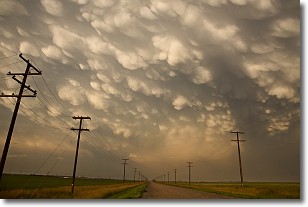
A mammatus cloud is a cloud with a unique feature which resembles
a web of pouches hanging along the base of the cloud.
In the United States, mammatus clouds tend to form in the warmer months, commonly
in the Midwest and eastern regions.
While they usually form at the bottom of a cumulonimbis cloud, they can also form
under altostratus, altocumulus, stratocumulus, and cirrus clouds. Mammatus clouds
warn that severe weather is close.
Next Topic: Nimbostratus Clouds
Current conditions powered by WeatherAPI.com


