Weather Alert in Oklahoma
Flood Advisory issued August 26 at 7:52PM CDT until August 27 at 1:00PM CDT by NWS Norman OK
AREAS AFFECTED: Blaine, OK; Caddo, OK; Canadian, OK; Grady, OK
DESCRIPTION: ...The Flood Advisory continues for the following rivers in Oklahoma... Canadian River near Bridgeport affecting Grady, Caddo, Blaine and Canadian Counties. * WHAT...Flooding caused by excessive rainfall continues. * WHERE...Canadian River near Bridgeport. * WHEN...Until early tomorrow afternoon. * IMPACTS...At 12.0 feet, The river remains within its banks in southern Blaine... northern Caddo... and southwestern Canadian counties. Low-lying bottomlands near the river may be cut off from easy access by high water in side channels. * ADDITIONAL DETAILS... - There is no current observed data. The estimated stage is 11.8 feet. - Bankfull stage is 14.0 feet. - Forecast...The Canadian River is expect to rise to 12.1 feet just after midnight then is expected to fall. - Action stage is 12.0 feet. - Flood stage is 14.0 feet. - http://www.weather.gov/safety/flood
INSTRUCTION: If you encounter a flooded roadway, turn around and find an alternative route. Additional information is available at www.weather.gov.
Want more detail? Get the Complete 7 Day and Night Detailed Forecast!
Current U.S. National Radar--Current
The Current National Weather Radar is shown below with a UTC Time (subtract 5 hours from UTC to get Eastern Time).

National Weather Forecast--Current
The Current National Weather Forecast and National Weather Map are shown below.

National Weather Forecast for Tomorrow
Tomorrow National Weather Forecast and Tomorrow National Weather Map are show below.

North America Water Vapor (Moisture)
This map shows recent moisture content over North America. Bright and colored areas show high moisture (ie, clouds); brown indicates very little moisture present; black indicates no moisture.

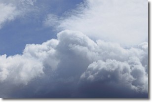
Weather Topic: What are Nimbostratus Clouds?
Home - Education - Cloud Types - Nimbostratus Clouds
 Next Topic: Precipitation
A nimbostratus cloud is similar to a stratus cloud in its formless,
smooth appearance. However, a nimbostratus cloud is darker than a stratus cloud,
because it is thicker.
Unlike a stratus cloud, a nimbostratus cloud typically brings with it the threat
of moderate to heavy precipitation. In some cases, the precipitation may evaporate
before reaching the ground, a phenomenon known as virga.
Next Topic: Precipitation
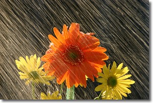
Weather Topic: What is Rain?
Home - Education - Precipitation - Rain
 Next Topic: Shelf Clouds
Precipitation in the form of water droplets is called rain.
Rain generally has a tendency to fall with less intensity over a greater period
of time, and when rainfall is more severe it is usually less sustained.
Rain is the most common form of precipitation and happens with greater frequency
depending on the season and regional influences. Cities have been shown to have
an observable effect on rainfall, due to an effect called the urban heat island.
Compared to upwind, monthly rainfall between twenty and forty miles downwind of
cities is 30% greater.
Next Topic: Shelf Clouds
Current conditions powered by WeatherAPI.com


