Weather Alert in Idaho
Flood Warning issued March 14 at 8:48AM PDT until March 15 at 7:48AM PDT by NWS Spokane WA
AREAS AFFECTED: Latah, ID; Whitman, WA
DESCRIPTION: ...Observed flooding increased in duration for the following rivers in Washington...Idaho... Paradise Creek at Moscow affecting Latah and Whitman Counties. For the Paradise Creek ...including Moscow...Moderate flooding is forecast. * WHAT...Record flooding is occurring. * WHERE...Paradise Creek at Moscow. * WHEN...Until tomorrow morning. * IMPACTS...At 11.3 feet, Flooding will increase across many streets and impact homes in the flood plain, including the intersection of E and Harding street, Lemhi at Mountain View street, Blaine at White street, and portions of the University of Idaho campus. Similar to the flooding of 2019. * ADDITIONAL DETAILS... - At 7:45 AM PDT Saturday the stage was 11.5 feet. - Bankfull stage is 8.0 feet. - Recent Activity...The maximum river stage in the 24 hours ending at 7:45 AM PDT Saturday was 11.5 feet. - Forecast...The river is expected to recede into its minor flood stage by Saturday afternoon and into its action stage by Sunday morning. It is forecasted to remain in action stage through Monday. - Flood stage is 9.2 feet. - Flood History...This crest compares to a previous crest of 11.4 feet on 04/09/2019. - http://www.weather.gov/safety/flood
INSTRUCTION: Turn around, don't drown when encountering flooded roads. Most flood deaths occur in vehicles. Caution is urged when walking near riverbanks. Motorists should not attempt to drive around barricades or drive cars through flooded areas. Additional information is available at www.weather.gov. The next statement will be issued this evening at 930 PM PDT.
Want more detail? Get the Complete 7 Day and Night Detailed Forecast!
Current U.S. National Radar--Current
The Current National Weather Radar is shown below with a UTC Time (subtract 5 hours from UTC to get Eastern Time).

National Weather Forecast--Current
The Current National Weather Forecast and National Weather Map are shown below.

National Weather Forecast for Tomorrow
Tomorrow National Weather Forecast and Tomorrow National Weather Map are show below.

North America Water Vapor (Moisture)
This map shows recent moisture content over North America. Bright and colored areas show high moisture (ie, clouds); brown indicates very little moisture present; black indicates no moisture.

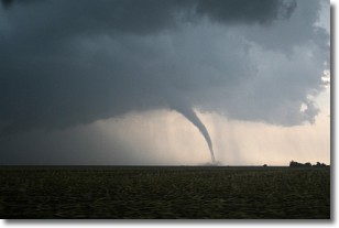
Weather Topic: What are Wall Clouds?
Home - Education - Cloud Types - Wall Clouds
 Next Topic: Altocumulus Clouds
A wall cloud forms underneath the base of a cumulonimbus cloud,
and can be a hotbed for deadly tornadoes.
Wall clouds are formed by air flowing into the cumulonimbus clouds, which can
result in the wall cloud descending from the base of the cumulonimbus cloud, or
rising fractus clouds which join to the base of the storm cloud as the wall cloud
takes shape.
Wall clouds can be very large, and in the Northern Hemisphere they generally
form at the southern edge of cumulonimbus clouds.
Next Topic: Altocumulus Clouds
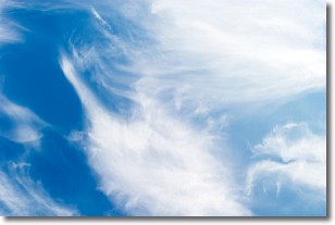
Weather Topic: What are Altostratus Clouds?
Home - Education - Cloud Types - Altostratus Clouds
 Next Topic: Cirrocumulus Clouds
Altostratus clouds form at mid to high-level altitudes
(between 2 and 7 km) and are created by a warm, stable air mass which causes
water vapor
to condense as it rise through the atmosphere. Usually altostratus clouds are
featureless sheets characterized by a uniform color.
In some cases, wind punching through the cloud formation may give it a waved
appearance, called altostratus undulatus. Altostratus clouds
are commonly seen with other cloud formations accompanying them.
Next Topic: Cirrocumulus Clouds
Current conditions powered by WeatherAPI.com


