Weather Alert in Idaho
Avalanche Warning issued February 23 at 5:54PM PST by NWS Spokane WA
AREAS AFFECTED: Bonner, ID; Boundary, ID; Shoshone, ID
DESCRIPTION: AVWOTX BACKCOUNTRY AVALANCHE WARNING 16:00 PST Mon Feb 23 2026 The Idaho Panhandle Avalanche Center in Sandpoint has issued a BACKCOUNTRY AVALANCHE WARNING for the following areas: NWS Missoula MT - MTZ001 (MTZ001) NWS Spokane WA - ID 017 (Bonner County)...ID 021 (Boundary County)...ID 079 (Shoshone County) * WHAT...An Avalanche Warning is in effect from Monday 4 PM to Tuesday 4 PM. Very dangerous avalanche conditions have developed from heavy snowfall and strong winds, and will last through Tuesday. You can very easily trigger avalanches large enough to bury or kill you, and some will release spontaneously. Avoid travel in avalanche terrain during this period. * WHERE...The Selkirk Mountains, West and East Cabinet Mountains, Purcell Mountains, and the Bitterroot Mountains - Silver Valley above 4,000 feet. * WHEN...In effect from Mon 16:00 PST to Tue 16:00 PST. * IMPACTS...Dense snowfall and widespread drifting has formed dangerous slabs of snow over multiple fragile weak snow layers. The new snow is adding enough stress to the snowpack to cause a widespread cycle of avalanches large enough to bury, injure, or kill a person. Some of these avalanches could propagate widely across terrain features like ridges, and run long distances into mature forests, valley floors, or flat terrain. It will be very easy for backcountry travelers to trigger them. * PRECAUTIONARY / PREPAREDNESS ACTIONS...Travel in and around avalanche terrain is not recommended during this period. Consult http://www.idahopanhandleavalanche.org/ or www.avalanche.org for more detailed information. Similar avalanche danger may exist at locations outside the coverage area of this or any avalanche center.
INSTRUCTION: N/A
Want more detail? Get the Complete 7 Day and Night Detailed Forecast!
Current U.S. National Radar--Current
The Current National Weather Radar is shown below with a UTC Time (subtract 5 hours from UTC to get Eastern Time).

National Weather Forecast--Current
The Current National Weather Forecast and National Weather Map are shown below.

National Weather Forecast for Tomorrow
Tomorrow National Weather Forecast and Tomorrow National Weather Map are show below.

North America Water Vapor (Moisture)
This map shows recent moisture content over North America. Bright and colored areas show high moisture (ie, clouds); brown indicates very little moisture present; black indicates no moisture.

Weather Topic: What are Cirrus Clouds?
Home - Education - Cloud Types - Cirrus Clouds
 Next Topic: Condensation
Cirrus clouds are high-level clouds that occur above 20,000 feet
and are composed mainly of ice crystals.
They are thin and wispy in appearance.
What do they indicate?
They are often the first sign of an approaching storm.
Next Topic: Condensation
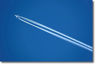
Weather Topic: What are Contrails?
Home - Education - Cloud Types - Contrails
 Next Topic: Cumulonimbus Clouds
A contrail is an artificial cloud, created by the passing of an
aircraft.
Contrails form because water vapor in the exhaust of aircraft engines is suspended
in the air under certain temperatures and humidity conditions. These contrails
are called exhaust contrails.
Another type of contrail can form due to a temporary reduction in air pressure
moving over the plane's surface, causing condensation.
These are called aerodynamic contrails.
When you can see your breath on a cold day, it is also because of condensation.
The reason contrails last longer than the condensation from your breath is
because the water in contrails freezes into ice particles.
Next Topic: Cumulonimbus Clouds
Current conditions powered by WeatherAPI.com


