Weather Alert in Illinois
Severe Thunderstorm Warning issued March 31 at 8:40AM CDT until March 31 at 9:00AM CDT by NWS Quad Cities IA IL
AREAS AFFECTED: Bureau, IL; Putnam, IL
DESCRIPTION: SVRDVN The National Weather Service in the Quad Cities has issued a * Severe Thunderstorm Warning for... Putnam County in north central Illinois... Southeastern Bureau County in north central Illinois... * Until 900 AM CDT. * At 840 AM CDT, a severe thunderstorm was located over Mark, or near Hennepin, moving east at 45 mph. HAZARD...Quarter size hail. SOURCE...Radar indicated. IMPACT...Damage to vehicles is expected. * Locations impacted include... Hennepin, Spring Valley, DePue, Granville, Ladd, Dalzell, Bureau Junction, McNabb, Putnam, Mark, Seatonville, Standard, Hollowayville, Ottville, and Florid. This includes the following highways... Interstate 80 in Illinois between mile markers 64 and 73. Interstate 180 between mile markers 1 and 3.
INSTRUCTION: For your protection move to an interior room on the lowest floor of a sturdy building.
Want more detail? Get the Complete 7 Day and Night Detailed Forecast!
Current U.S. National Radar--Current
The Current National Weather Radar is shown below with a UTC Time (subtract 5 hours from UTC to get Eastern Time).

National Weather Forecast--Current
The Current National Weather Forecast and National Weather Map are shown below.

National Weather Forecast for Tomorrow
Tomorrow National Weather Forecast and Tomorrow National Weather Map are show below.

North America Water Vapor (Moisture)
This map shows recent moisture content over North America. Bright and colored areas show high moisture (ie, clouds); brown indicates very little moisture present; black indicates no moisture.

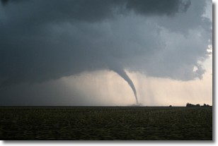
Weather Topic: What are Wall Clouds?
Home - Education - Cloud Types - Wall Clouds
 Next Topic: Altocumulus Clouds
A wall cloud forms underneath the base of a cumulonimbus cloud,
and can be a hotbed for deadly tornadoes.
Wall clouds are formed by air flowing into the cumulonimbus clouds, which can
result in the wall cloud descending from the base of the cumulonimbus cloud, or
rising fractus clouds which join to the base of the storm cloud as the wall cloud
takes shape.
Wall clouds can be very large, and in the Northern Hemisphere they generally
form at the southern edge of cumulonimbus clouds.
Next Topic: Altocumulus Clouds
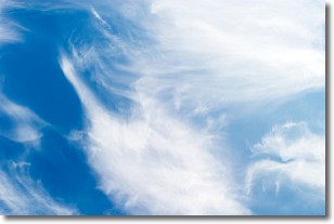
Weather Topic: What are Altostratus Clouds?
Home - Education - Cloud Types - Altostratus Clouds
 Next Topic: Cirrocumulus Clouds
Altostratus clouds form at mid to high-level altitudes
(between 2 and 7 km) and are created by a warm, stable air mass which causes
water vapor
to condense as it rise through the atmosphere. Usually altostratus clouds are
featureless sheets characterized by a uniform color.
In some cases, wind punching through the cloud formation may give it a waved
appearance, called altostratus undulatus. Altostratus clouds
are commonly seen with other cloud formations accompanying them.
Next Topic: Cirrocumulus Clouds
Current conditions powered by WeatherAPI.com


