Weather Alert in Illinois
Severe Thunderstorm Warning issued March 31 at 8:40AM CDT until March 31 at 9:00AM CDT by NWS Quad Cities IA IL
AREAS AFFECTED: Bureau, IL; Putnam, IL
DESCRIPTION: SVRDVN The National Weather Service in the Quad Cities has issued a * Severe Thunderstorm Warning for... Putnam County in north central Illinois... Southeastern Bureau County in north central Illinois... * Until 900 AM CDT. * At 840 AM CDT, a severe thunderstorm was located over Mark, or near Hennepin, moving east at 45 mph. HAZARD...Quarter size hail. SOURCE...Radar indicated. IMPACT...Damage to vehicles is expected. * Locations impacted include... Hennepin, Spring Valley, DePue, Granville, Ladd, Dalzell, Bureau Junction, McNabb, Putnam, Mark, Seatonville, Standard, Hollowayville, Ottville, and Florid. This includes the following highways... Interstate 80 in Illinois between mile markers 64 and 73. Interstate 180 between mile markers 1 and 3.
INSTRUCTION: For your protection move to an interior room on the lowest floor of a sturdy building.
Want more detail? Get the Complete 7 Day and Night Detailed Forecast!
Current U.S. National Radar--Current
The Current National Weather Radar is shown below with a UTC Time (subtract 5 hours from UTC to get Eastern Time).

National Weather Forecast--Current
The Current National Weather Forecast and National Weather Map are shown below.

National Weather Forecast for Tomorrow
Tomorrow National Weather Forecast and Tomorrow National Weather Map are show below.

North America Water Vapor (Moisture)
This map shows recent moisture content over North America. Bright and colored areas show high moisture (ie, clouds); brown indicates very little moisture present; black indicates no moisture.

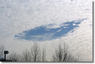
Weather Topic: What are Hole Punch Clouds?
Home - Education - Cloud Types - Hole Punch Clouds
 Next Topic: Mammatus Clouds
A hole punch cloud is an unusual occurrence when a disk-shaped
hole appears in a cirrostratus, cirrocumulus, or altocumulus cloud.
When part of the cloud forms ice crystals, water droplets in the surrounding area
of the cloud evaporate. The effect of this process produces a large elliptical
gap in the cloud. The hole punch cloud formation is rare, but it is not specific
to any geographic area.
Other names which have been used to describe this phenomena include fallstreak hole,
skypunch, and cloud hole.
Next Topic: Mammatus Clouds
Weather Topic: What are Nimbostratus Clouds?
Home - Education - Cloud Types - Nimbostratus Clouds
 Next Topic: Precipitation
A nimbostratus cloud is similar to a stratus cloud in its formless,
smooth appearance. However, a nimbostratus cloud is darker than a stratus cloud,
because it is thicker.
Unlike a stratus cloud, a nimbostratus cloud typically brings with it the threat
of moderate to heavy precipitation. In some cases, the precipitation may evaporate
before reaching the ground, a phenomenon known as virga.
Next Topic: Precipitation
Current conditions powered by WeatherAPI.com


