Weather Alert in Hawaii
High Wind Warning issued February 8 at 10:54AM HST until February 9 at 6:00PM HST by NWS Honolulu HI
AREAS AFFECTED: Kauai Southwest; Kauai Mountains; Waianae Coast; Central Oahu; Waianae Mountains; Lanai Mauka; Kahoolawe; Maui Leeward West; Kohala; Big Island Interior; Kauai South; Honolulu Metro; Ewa Plain; Koolau Leeward; Molokai West; Molokai Leeward South; Lanai Windward; Lanai Leeward; Lanai South; Maui Central Valley North; Maui Central Valley South
DESCRIPTION: * WHAT...Northeast winds 25 to 35 mph gusting to 60 mph, with some locally higher gusts up to 70 mph. * WHERE...All Hawaiian islands. * WHEN...Until 6 PM HST Monday. * IMPACTS...Damaging winds may blow down trees and power lines and damage roofs. Power outages are possible. Travel will be difficult, especially for high profile vehicles.
INSTRUCTION: Strong winds may lead to property damage. Hazardous driving conditions due to powerful cross winds will pose a serious risk for drivers, especially for light weight and high profile vehicles. Loose outdoor items should be brought inside or secured properly. A High Wind Warning means that winds are expected to be at least 40 mph, with gusts over 60 mph. Stay away from downed power lines.
Want more detail? Get the Complete 7 Day and Night Detailed Forecast!
Current U.S. National Radar--Current
The Current National Weather Radar is shown below with a UTC Time (subtract 5 hours from UTC to get Eastern Time).

National Weather Forecast--Current
The Current National Weather Forecast and National Weather Map are shown below.

National Weather Forecast for Tomorrow
Tomorrow National Weather Forecast and Tomorrow National Weather Map are show below.

North America Water Vapor (Moisture)
This map shows recent moisture content over North America. Bright and colored areas show high moisture (ie, clouds); brown indicates very little moisture present; black indicates no moisture.

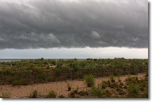
Weather Topic: What are Shelf Clouds?
Home - Education - Cloud Types - Shelf Clouds
 Next Topic: Sleet
A shelf cloud is similar to a wall cloud, but forms at the front
of a storm cloud, instead of at the rear, where wall clouds form.
A shelf cloud is caused by a series of events set into motion by the advancing
storm; first, cool air settles along the ground where precipitation has just fallen.
As the cool air is brought in, the warmer air is displaced, and rises above it,
because it is less dense. When the warmer air reaches the bottom of the storm cloud,
it begins to cool again, and the resulting condensation is a visible shelf cloud.
Next Topic: Sleet
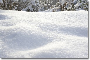
Weather Topic: What is Snow?
Home - Education - Precipitation - Snow
 Next Topic: Stratocumulus Clouds
Snow is precipitation taking the form of ice crystals. Each ice crystal, or snowflake,
has unique characteristics, but all of them grow in a hexagonal structure.
Snowfall can last for sustained periods of time and result in significant buildup
of snow on the ground.
On the earth's surface, snow starts out light and powdery, but as it begins to melt
it tends to become more granular, producing small bits of ice which have the consistency of
sand. After several cycles of melting and freezing, snow can become very dense
and ice-like, commonly known as snow pack.
Next Topic: Stratocumulus Clouds
Current conditions powered by WeatherAPI.com


