Weather Alert in Hawaii
High Wind Warning issued February 8 at 10:54AM HST until February 9 at 6:00PM HST by NWS Honolulu HI
AREAS AFFECTED: Kauai Southwest; Kauai Mountains; Waianae Coast; Central Oahu; Waianae Mountains; Lanai Mauka; Kahoolawe; Maui Leeward West; Kohala; Big Island Interior; Kauai South; Honolulu Metro; Ewa Plain; Koolau Leeward; Molokai West; Molokai Leeward South; Lanai Windward; Lanai Leeward; Lanai South; Maui Central Valley North; Maui Central Valley South
DESCRIPTION: * WHAT...Northeast winds 25 to 35 mph gusting to 60 mph, with some locally higher gusts up to 70 mph. * WHERE...All Hawaiian islands. * WHEN...Until 6 PM HST Monday. * IMPACTS...Damaging winds may blow down trees and power lines and damage roofs. Power outages are possible. Travel will be difficult, especially for high profile vehicles.
INSTRUCTION: Strong winds may lead to property damage. Hazardous driving conditions due to powerful cross winds will pose a serious risk for drivers, especially for light weight and high profile vehicles. Loose outdoor items should be brought inside or secured properly. A High Wind Warning means that winds are expected to be at least 40 mph, with gusts over 60 mph. Stay away from downed power lines.
Want more detail? Get the Complete 7 Day and Night Detailed Forecast!
Current U.S. National Radar--Current
The Current National Weather Radar is shown below with a UTC Time (subtract 5 hours from UTC to get Eastern Time).

National Weather Forecast--Current
The Current National Weather Forecast and National Weather Map are shown below.

National Weather Forecast for Tomorrow
Tomorrow National Weather Forecast and Tomorrow National Weather Map are show below.

North America Water Vapor (Moisture)
This map shows recent moisture content over North America. Bright and colored areas show high moisture (ie, clouds); brown indicates very little moisture present; black indicates no moisture.

Weather Topic: What is Condensation?
Home - Education - Precipitation - Condensation
 Next Topic: Contrails
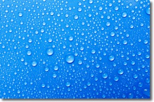
Condensation is the process which creates clouds, and therefore
it is a crucial process in the water cycle.
Condensation is the change of matter from a state of gas into a state of liquid,
and it happens because water molecules release heat into the atmosphere and
become organized into a more closely packed structure, what we might see as
water droplets.
Water is always present in the air around us as a vapor, but it's too small for
us to see. When water undergoes the process of condensation it becomes organized
into visible water droplets. You've probably seen condensation happen before on the
surface of a cold drink!
Next Topic: Contrails
Weather Topic: What are Cumulonimbus Clouds?
Home - Education - Cloud Types - Cumulonimbus Clouds
 Next Topic: Cumulus Clouds
The final form taken by a growing cumulus cloud is the
cumulonimbus cloud, which is very tall and dense.
The tower of a cumulonimbus cloud can soar 23 km into the atmosphere, although
most commonly they stop growing at an altitude of 6 km.
Even small cumulonimbus clouds appear very large in comparison to other cloud types.
They can signal the approach of stormy weather, such as thunderstorms or blizzards.
Next Topic: Cumulus Clouds
Current conditions powered by WeatherAPI.com


