Weather Alert in Alaska
Hydrologic Outlook issued August 30 at 9:40PM AKDT by NWS Fairbanks AK
AREAS AFFECTED: Fairbanks Metro Area
DESCRIPTION: ESFAFG As of 9 PM on Saturday, the Tanana River at Fairbanks has risen to 23.74 feet and water levels are still rising. Flooding impacts are not expected at this time, but those near the Tanana River outside of the dike may observe high groundwater levels. While it is still somewhat uncertain exactly how much the Tanana will rise before cresting and receding, river levels will likely approach 24 feet either tomorrow or Labor Day. At this level, while no specific flood impacts will be realized, bankfull conditions will be noted in the vicinity of Old Richardson Hwy in Salcha, and water may begin to spill over the bank and approach Ruger Trail near Bradbury Road. Tanana River water has a history of beginning to flow into the Piledriver Slough as well when river levels in the Tanana at Fairbanks reach 24 feet. Additional rainfall amounts over the next few days in Fairbanks and upstream areas are expected to remain under a quarter of an inch. As such, any further rainfall this weekend is not expected to bring additional impacts to locations in Fairbanks near the Tanana.
INSTRUCTION: N/A
Want more detail? Get the Complete 7 Day and Night Detailed Forecast!
Current U.S. National Radar--Current
The Current National Weather Radar is shown below with a UTC Time (subtract 5 hours from UTC to get Eastern Time).

National Weather Forecast--Current
The Current National Weather Forecast and National Weather Map are shown below.

National Weather Forecast for Tomorrow
Tomorrow National Weather Forecast and Tomorrow National Weather Map are show below.

North America Water Vapor (Moisture)
This map shows recent moisture content over North America. Bright and colored areas show high moisture (ie, clouds); brown indicates very little moisture present; black indicates no moisture.

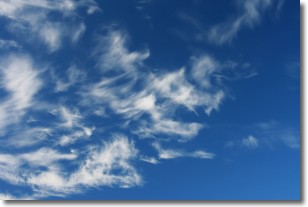
Weather Topic: What are Cirrostratus Clouds?
Home - Education - Cloud Types - Cirrostratus Clouds
 Next Topic: Cirrus Clouds
Cirrostratus clouds are high, thin clouds that form above
20,000 feet and are made mostly of ice crystals. They sometimes look like giant
feathers, horse tails, or curls of hair in the sky.
These clouds are pushed by the jet stream and can move at high speeds reaching
100 mph.
What do they indicate?
They indicate that a precipitation is likely within 24 hours.
Next Topic: Cirrus Clouds
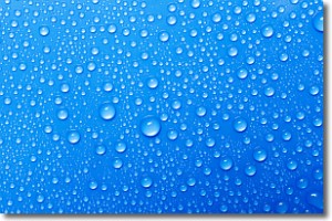
Weather Topic: What is Condensation?
Home - Education - Precipitation - Condensation
 Next Topic: Contrails
Condensation is the process which creates clouds, and therefore
it is a crucial process in the water cycle.
Condensation is the change of matter from a state of gas into a state of liquid,
and it happens because water molecules release heat into the atmosphere and
become organized into a more closely packed structure, what we might see as
water droplets.
Water is always present in the air around us as a vapor, but it's too small for
us to see. When water undergoes the process of condensation it becomes organized
into visible water droplets. You've probably seen condensation happen before on the
surface of a cold drink!
Next Topic: Contrails
Current conditions powered by WeatherAPI.com


