Weather Alert in Washington
Flood Warning issued March 29 at 2:11PM PDT until April 5 at 8:30AM PDT by NWS Spokane WA
AREAS AFFECTED: Chelan, WA
DESCRIPTION: * WHAT...Flooding caused by snowmelt continues for the lower Stehekin Valley. * WHERE...A portion of North Central Washington, including the following county, Chelan. * WHEN...Until further notice. * IMPACTS...When the Stehekin River gauge hits 19.3 feet, water breaches the river bank. At 20 feet, water inundates some properties and overtops the temporary corduroy bridge. Company Creek Road begins to flood in places at the northern end and Battalion Creek culverts are beginning to be overtopped. At 20.5 feet, water begins to damage Wood Road. * ADDITIONAL DETAILS... - At 208 PM PDT, Snowmelt continues to contribute to high floods and flooding on the Stehekin River. - Little precipitation over the past couple of days has allowed the Stehekin River to slowly recede. This trend will continue through the week, but it is forecasted to remain near or above 20 feet until further notice. - http://www.weather.gov/safety/flood
INSTRUCTION: Flooding is occurring. It is important to know where you are relative to streams, rivers, or creeks. Campers and hikers should avoid streams or creeks.
Want more detail? Get the Complete 7 Day and Night Detailed Forecast!
Current U.S. National Radar--Current
The Current National Weather Radar is shown below with a UTC Time (subtract 5 hours from UTC to get Eastern Time).

National Weather Forecast--Current
The Current National Weather Forecast and National Weather Map are shown below.

National Weather Forecast for Tomorrow
Tomorrow National Weather Forecast and Tomorrow National Weather Map are show below.

North America Water Vapor (Moisture)
This map shows recent moisture content over North America. Bright and colored areas show high moisture (ie, clouds); brown indicates very little moisture present; black indicates no moisture.

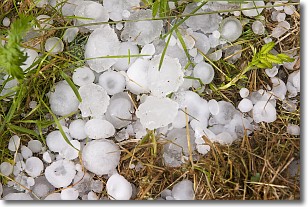
Weather Topic: What is Hail?
Home - Education - Precipitation - Hail
 Next Topic: Hole Punch Clouds
Hail is a form of precipitation which is recognized by large solid balls or
clumps of ice. Hail is created by thunderstorm clouds with strong updrafts of wind.
As the hailstones remain in the updraft, ice is deposited onto them until their
weight becomes heavy enough for them to fall to the earth's surface.
Hail storms can cause significant damage to crops, aircrafts, and man-made structures,
despite the fact that the duration is usually less than ten minutes.
Next Topic: Hole Punch Clouds
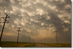
Weather Topic: What are Mammatus Clouds?
Home - Education - Cloud Types - Mammatus Clouds
 Next Topic: Nimbostratus Clouds
A mammatus cloud is a cloud with a unique feature which resembles
a web of pouches hanging along the base of the cloud.
In the United States, mammatus clouds tend to form in the warmer months, commonly
in the Midwest and eastern regions.
While they usually form at the bottom of a cumulonimbis cloud, they can also form
under altostratus, altocumulus, stratocumulus, and cirrus clouds. Mammatus clouds
warn that severe weather is close.
Next Topic: Nimbostratus Clouds
Current conditions powered by WeatherAPI.com


