Weather Alert in Idaho
Avalanche Warning issued February 24 at 11:47AM MST by NWS Boise ID
AREAS AFFECTED: Adams, ID; Idaho, ID; Valley, ID
DESCRIPTION: The following message is transmitted at the request of the Payette National Forest Avalanche Center. ...The Payette National Forest Avalanche Center in McCall Idaho has issued a BACKCOUNTRY AVALANCHE WARNING... * WHAT...The avalanche danger for the West Central Mountains of Idaho will rise to HIGH on Tuesday afternoon and into Wednesday morning. Rain on snow and heavy, wet snow will create very dangerous avalanche conditions. * WHERE...The West Central Mountains of Idaho, including mountains near the communities of McCall, New Meadows, Donnelly, Cascade, and Yellow Pine. * WHEN...In effect from Tuesday 11:25 MST to Wednesday 11:45 MST. * IMPACTS...A warm, wet storm is bringing wet, heavy snowfall and rising rain levels up to 7000'. Natural and human-triggered avalanches large enough to bury people are very likely to occur. Even smaller steep slopes, like roadcuts, may also avalanche, depositing a surprising amount of debris on the road below.
INSTRUCTION: *Travel on or underneath slopes steeper than 30 degrees is not recommended. Avalanches may run onto groomed snowmobile trails. Pay attention to the terrain above you as conditions change and as more snow and rain fall by the afternoon. Avalanches may impact roadways along the South Fork of the Salmon, Warm Lake Summit, and East Fork South Fork. Consult WWW.PAYETTEAVALANCHE.ORG or WWW.AVALANCHE.ORG for more detailed information. Similar avalanche danger may exist at locations outside the coverage area of this or any avalanche center. LAT...LON 4491 11627 4497 11622 4488 11606 4440 11601 4429 11609 4431 11620 4439 11626 4461 11628 4468 11635 4479 11634 4485 11626
Want more detail? Get the Complete 7 Day and Night Detailed Forecast!
Current U.S. National Radar--Current
The Current National Weather Radar is shown below with a UTC Time (subtract 5 hours from UTC to get Eastern Time).

National Weather Forecast--Current
The Current National Weather Forecast and National Weather Map are shown below.

National Weather Forecast for Tomorrow
Tomorrow National Weather Forecast and Tomorrow National Weather Map are show below.

North America Water Vapor (Moisture)
This map shows recent moisture content over North America. Bright and colored areas show high moisture (ie, clouds); brown indicates very little moisture present; black indicates no moisture.

Weather Topic: What are Contrails?
Home - Education - Cloud Types - Contrails
 Next Topic: Cumulonimbus Clouds
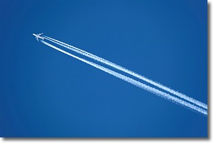
A contrail is an artificial cloud, created by the passing of an
aircraft.
Contrails form because water vapor in the exhaust of aircraft engines is suspended
in the air under certain temperatures and humidity conditions. These contrails
are called exhaust contrails.
Another type of contrail can form due to a temporary reduction in air pressure
moving over the plane's surface, causing condensation.
These are called aerodynamic contrails.
When you can see your breath on a cold day, it is also because of condensation.
The reason contrails last longer than the condensation from your breath is
because the water in contrails freezes into ice particles.
Next Topic: Cumulonimbus Clouds
Weather Topic: What are Cumulus Clouds?
Home - Education - Cloud Types - Cumulus Clouds
 Next Topic: Drizzle
Cumulus clouds are fluffy and textured with rounded tops, and
may have flat bottoms. The border of a cumulus cloud
is clearly defined, and can have the appearance of cotton or cauliflower.
Cumulus clouds form at low altitudes (rarely above 2 km) but can grow very tall,
becoming cumulus congestus and possibly the even taller cumulonimbus clouds.
When cumulus clouds become taller, they have a greater chance of producing precipitation.
Next Topic: Drizzle
Current conditions powered by WeatherAPI.com


