Weather Alert in Idaho
Avalanche Warning issued February 24 at 7:58PM MST by NWS Pocatello ID
AREAS AFFECTED: Caribou Range; Big Hole Mountains
DESCRIPTION: AVWPIH * WHAT...Avalanche warning. The avalanche danger is high due to heavy rates of snowfall and intense wind. * WHERE...The mountains of southeast Idaho including the Snake River Range, Caribou Range, and Big Holes. The mountains of western Wyoming including the Tetons, Snake River, Salt River, and Wyoming ranges. * WHEN...In effect from Tuesday at 10 PM MST to Wednesday at 10 PM MST. * IMPACTS...Heavy snowfall combined with strong wind will create widespread areas of unstable snow and overload buried weak layers. Natural and human-triggered avalanches will be very likely across all aspects above 7,000 feet for backcountry recreationalists.
INSTRUCTION: Very dangerous avalanche conditions. Travel in avalanche terrain is not recommended. Gentle terrain below large avalanche paths could be impacted. Consult www.btavy.org or www.avalanche.org for more detailed information. Similar avalanche danger may exist at locations outside the coverage area of this or any avalanche center.
Want more detail? Get the Complete 7 Day and Night Detailed Forecast!
Current U.S. National Radar--Current
The Current National Weather Radar is shown below with a UTC Time (subtract 5 hours from UTC to get Eastern Time).

National Weather Forecast--Current
The Current National Weather Forecast and National Weather Map are shown below.

National Weather Forecast for Tomorrow
Tomorrow National Weather Forecast and Tomorrow National Weather Map are show below.

North America Water Vapor (Moisture)
This map shows recent moisture content over North America. Bright and colored areas show high moisture (ie, clouds); brown indicates very little moisture present; black indicates no moisture.

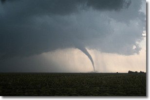
Weather Topic: What are Wall Clouds?
Home - Education - Cloud Types - Wall Clouds
 Next Topic: Altocumulus Clouds
A wall cloud forms underneath the base of a cumulonimbus cloud,
and can be a hotbed for deadly tornadoes.
Wall clouds are formed by air flowing into the cumulonimbus clouds, which can
result in the wall cloud descending from the base of the cumulonimbus cloud, or
rising fractus clouds which join to the base of the storm cloud as the wall cloud
takes shape.
Wall clouds can be very large, and in the Northern Hemisphere they generally
form at the southern edge of cumulonimbus clouds.
Next Topic: Altocumulus Clouds
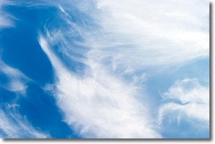
Weather Topic: What are Altostratus Clouds?
Home - Education - Cloud Types - Altostratus Clouds
 Next Topic: Cirrocumulus Clouds
Altostratus clouds form at mid to high-level altitudes
(between 2 and 7 km) and are created by a warm, stable air mass which causes
water vapor
to condense as it rise through the atmosphere. Usually altostratus clouds are
featureless sheets characterized by a uniform color.
In some cases, wind punching through the cloud formation may give it a waved
appearance, called altostratus undulatus. Altostratus clouds
are commonly seen with other cloud formations accompanying them.
Next Topic: Cirrocumulus Clouds
Current conditions powered by WeatherAPI.com


