Weather Alert in New Mexico
Red Flag Warning issued March 14 at 11:37PM MDT until March 15 at 8:00PM MDT by NWS Albuquerque NM
AREAS AFFECTED: Northwest Plateau; West Central Mountains; Middle Rio Grande Valley; West Central Basin and Range; North Central Mountains; Upper Rio Grande Valley and Lower Chama River Valley; Sangre de Cristo Mountains; Sandia and Manzano Mountains; East Central Plains
DESCRIPTION: ...RED FLAG WARNING FROM 9 AM TO 8 PM SUNDAY FOR ALL OF NORTHERN AND CENTRAL NM DUE TO STRONG TO SEVERE WINDS AND LOW HUMIDITY... .On Sunday, widespread critical fire weather will develop. Winds will turn very strong to potentially damaging as both a Pacific and backdoor cold front pass through the area. With gusts between 40 and 65 mph and single digit humidity values in many areas, critical to extreme fire weather conditions are likely despite cooling temperatures. * AREA AND TIMING...Northwest Plateau (Zone 101), West Central Mountains (Zone 105), Middle Rio Grande Valley (Zone 106), West Central Basin and Range (Zone 109), North Central Mountains (Zone 120), Upper Rio Grande Valley and Lower Chama River Valley (Zone 121), Sangre de Cristo Mountains (Zone 122), Sandia and Manzano Mountains (Zone 124), and East Central Plains (Zone 126) on Sunday from 9 AM through 8 PM. * 20 FOOT WINDS...North northwest winds 25 to 40 mph with gusts between 45 and 65 mph Sunday. * RELATIVE HUMIDITY...Minimum values between 6 and 15 percent with locally higher values across the peaks of the Tusas Mountains and Sangre de Cristo Mountains. * IMPACTS...Any fires that develop will likely spread rapidly. Outdoor burning is not recommended.
INSTRUCTION: Please advise the appropriate officials or fire crews in the field of this Red Flag Warning.
Want more detail? Get the Complete 7 Day and Night Detailed Forecast!
Current U.S. National Radar--Current
The Current National Weather Radar is shown below with a UTC Time (subtract 5 hours from UTC to get Eastern Time).

National Weather Forecast--Current
The Current National Weather Forecast and National Weather Map are shown below.

National Weather Forecast for Tomorrow
Tomorrow National Weather Forecast and Tomorrow National Weather Map are show below.

North America Water Vapor (Moisture)
This map shows recent moisture content over North America. Bright and colored areas show high moisture (ie, clouds); brown indicates very little moisture present; black indicates no moisture.

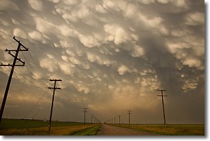
Weather Topic: What are Mammatus Clouds?
Home - Education - Cloud Types - Mammatus Clouds
 Next Topic: Nimbostratus Clouds
A mammatus cloud is a cloud with a unique feature which resembles
a web of pouches hanging along the base of the cloud.
In the United States, mammatus clouds tend to form in the warmer months, commonly
in the Midwest and eastern regions.
While they usually form at the bottom of a cumulonimbis cloud, they can also form
under altostratus, altocumulus, stratocumulus, and cirrus clouds. Mammatus clouds
warn that severe weather is close.
Next Topic: Nimbostratus Clouds
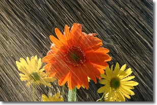
Weather Topic: What is Precipitation?
Home - Education - Precipitation - Precipitation
 Next Topic: Rain
Precipitation can refer to many different forms of water that
may fall from clouds. Precipitation occurs after a cloud has become saturated to
the point where its water particles are more dense than the air below the cloud.
In most cases, precipitation will reach the ground, but it is not uncommon for
precipitation to evaporate before it reaches the earth's surface.
When precipitation evaporates before it contacts the ground it is called Virga.
Graupel, hail, sleet, rain, drizzle, and snow are forms of precipitation, but fog
and mist are not considered precipitation because the water vapor which
constitutes them isn't dense enough to fall to the ground.
Next Topic: Rain
Current conditions powered by WeatherAPI.com


