Weather Alert in Idaho
Flash Flood Watch issued August 26 at 2:11AM MDT until August 28 at 12:00AM MDT by NWS Pocatello ID
AREAS AFFECTED: Sawtooth/Stanley Basin
DESCRIPTION: * WHAT...Flash flooding and debris flows caused by excessive rainfall continue to be possible over the Wapiti burn scar. * WHERE...A portion of central Idaho, including the following area, Sawtooth/Stanley Basin. * WHEN...From noon MDT today through Wednesday evening. * IMPACTS...Heavy rainfall over the Wapiti burn scar is expected during the period of the watch. Anyone in or near the Wapiti burn scar should prepare for potential flooding impacts. Be sure to stay up to date with information from local authorities. Heavy rainfall could trigger flash flooding and debris flows in and near recent wildfire burn scars. Heavy rainfall could trigger flash flooding of low-lying areas, urbanized street flooding, and debris flows in and near recent wildfire burn scars. * ADDITIONAL DETAILS... - National Weather Service Meteorologists are forecasting heavy rainfall over the burn scar, which may lead to flash flooding and debris flows. - http://www.weather.gov/safety/flood
INSTRUCTION: You should monitor later forecasts and be prepared to take action should Flash Flood Warnings be issued.
Want more detail? Get the Complete 7 Day and Night Detailed Forecast!
Current U.S. National Radar--Current
The Current National Weather Radar is shown below with a UTC Time (subtract 5 hours from UTC to get Eastern Time).

National Weather Forecast--Current
The Current National Weather Forecast and National Weather Map are shown below.

National Weather Forecast for Tomorrow
Tomorrow National Weather Forecast and Tomorrow National Weather Map are show below.

North America Water Vapor (Moisture)
This map shows recent moisture content over North America. Bright and colored areas show high moisture (ie, clouds); brown indicates very little moisture present; black indicates no moisture.

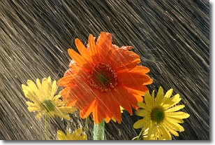
Weather Topic: What is Precipitation?
Home - Education - Precipitation - Precipitation
 Next Topic: Rain
Precipitation can refer to many different forms of water that
may fall from clouds. Precipitation occurs after a cloud has become saturated to
the point where its water particles are more dense than the air below the cloud.
In most cases, precipitation will reach the ground, but it is not uncommon for
precipitation to evaporate before it reaches the earth's surface.
When precipitation evaporates before it contacts the ground it is called Virga.
Graupel, hail, sleet, rain, drizzle, and snow are forms of precipitation, but fog
and mist are not considered precipitation because the water vapor which
constitutes them isn't dense enough to fall to the ground.
Next Topic: Rain
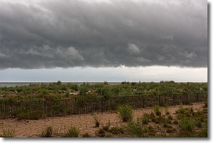
Weather Topic: What are Shelf Clouds?
Home - Education - Cloud Types - Shelf Clouds
 Next Topic: Sleet
A shelf cloud is similar to a wall cloud, but forms at the front
of a storm cloud, instead of at the rear, where wall clouds form.
A shelf cloud is caused by a series of events set into motion by the advancing
storm; first, cool air settles along the ground where precipitation has just fallen.
As the cool air is brought in, the warmer air is displaced, and rises above it,
because it is less dense. When the warmer air reaches the bottom of the storm cloud,
it begins to cool again, and the resulting condensation is a visible shelf cloud.
Next Topic: Sleet
Current conditions powered by WeatherAPI.com


