Weather Alert in Hawaii
High Surf Warning issued February 8 at 3:00PM HST until February 10 at 6:00AM HST by NWS Honolulu HI
AREAS AFFECTED: Olomana; Kahoolawe; Maui Windward West; Kauai East; East Honolulu; Koolau Windward; Molokai Windward; Molokai Southeast; Windward Haleakala; Kipahulu; South Haleakala; Big Island Southeast; Big Island East; Big Island North
DESCRIPTION: ...HIGH SURF WARNING FOR EAST FACING SHORES OF KAUAI OAHU MOLOKAI MAUI KAHOOLAWE AND BIG ISLAND... .Strong trade winds will bring large and very rough surf along east facing shores through Monday night. * WHAT...Surf 10 to 15 feet along east facing shores. * WHERE... East facing shores of Kauai, Oahu, Molokai, Maui Kahoolawe and the Big Island. * WHEN...Until 6 AM HST Tuesday. * IMPACTS...High. Expect very strong breaking waves and powerful currents. Waves breaking in channel entrances may make navigating the channels dangerous.
INSTRUCTION: Stay away from the shoreline along the affected coasts. Be prepared for road closures. Postpone entering or leaving channels affected by the high surf until the surf subsides.
Want more detail? Get the Complete 7 Day and Night Detailed Forecast!
Current U.S. National Radar--Current
The Current National Weather Radar is shown below with a UTC Time (subtract 5 hours from UTC to get Eastern Time).

National Weather Forecast--Current
The Current National Weather Forecast and National Weather Map are shown below.

National Weather Forecast for Tomorrow
Tomorrow National Weather Forecast and Tomorrow National Weather Map are show below.

North America Water Vapor (Moisture)
This map shows recent moisture content over North America. Bright and colored areas show high moisture (ie, clouds); brown indicates very little moisture present; black indicates no moisture.

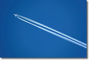
Weather Topic: What are Contrails?
Home - Education - Cloud Types - Contrails
 Next Topic: Cumulonimbus Clouds
A contrail is an artificial cloud, created by the passing of an
aircraft.
Contrails form because water vapor in the exhaust of aircraft engines is suspended
in the air under certain temperatures and humidity conditions. These contrails
are called exhaust contrails.
Another type of contrail can form due to a temporary reduction in air pressure
moving over the plane's surface, causing condensation.
These are called aerodynamic contrails.
When you can see your breath on a cold day, it is also because of condensation.
The reason contrails last longer than the condensation from your breath is
because the water in contrails freezes into ice particles.
Next Topic: Cumulonimbus Clouds
Weather Topic: What are Cumulus Clouds?
Home - Education - Cloud Types - Cumulus Clouds
 Next Topic: Drizzle
Cumulus clouds are fluffy and textured with rounded tops, and
may have flat bottoms. The border of a cumulus cloud
is clearly defined, and can have the appearance of cotton or cauliflower.
Cumulus clouds form at low altitudes (rarely above 2 km) but can grow very tall,
becoming cumulus congestus and possibly the even taller cumulonimbus clouds.
When cumulus clouds become taller, they have a greater chance of producing precipitation.
Next Topic: Drizzle
Current conditions powered by WeatherAPI.com


