Weather Alert in Florida
Flood Warning issued September 10 at 8:24PM EDT by NWS Melbourne FL
AREAS AFFECTED: Lake, FL; Volusia, FL
DESCRIPTION: ...The Flood Warning continues for the following rivers in Florida... St Johns River Near Astor affecting Lake and Volusia Counties. .On the Saint Johns River Near Astor, recent rainfall over the basin and increasing northerly winds have caused river levels to slowly rise. The river is now forecast to remain near Moderate flood stage for the next several days. However, any additional rainfall may cause further increases in the river levels. For the St. Johns River...including Astor...Moderate flooding is forecast. Additional information is available at www.weather.gov. The next statement will be issued Thursday morning at 1030 AM EDT. * WHAT...Minor flooding is occurring and moderate flooding is forecast. * WHERE...St Johns River near Astor. * WHEN...Until further notice. * IMPACTS...At 3.0 feet, Water approaches or may enter lowest homes on or near Wildhog Road and nearby canals. Flooding reaches the parking lot of the Juno Trail Apartments. Flooding on portions of Alligator Road and Holiday Road. Lowest lying yards along Blue Creek are flooded. Roads at Astor Landing Campground and Lake Dexter Boat Ramp begin to flood. Water enters lower homes closest to the river on McPherson Lane. * ADDITIONAL DETAILS... - At 7:30 PM EDT Wednesday the stage was 2.9 feet. - Bankfull stage is 2.0 feet. - Recent Activity...The maximum river stage in the 24 hours ending at 7:30 PM EDT Wednesday was 3.0 feet. - Forecast...The river is expected to rise to a crest of 3.0 feet just after midnight tonight, then hold steady near Moderate flood stage. - Flood stage is 2.3 feet. - http://www.weather.gov/safety/flood
INSTRUCTION: N/A
Want more detail? Get the Complete 7 Day and Night Detailed Forecast!
Current U.S. National Radar--Current
The Current National Weather Radar is shown below with a UTC Time (subtract 5 hours from UTC to get Eastern Time).

National Weather Forecast--Current
The Current National Weather Forecast and National Weather Map are shown below.

National Weather Forecast for Tomorrow
Tomorrow National Weather Forecast and Tomorrow National Weather Map are show below.

North America Water Vapor (Moisture)
This map shows recent moisture content over North America. Bright and colored areas show high moisture (ie, clouds); brown indicates very little moisture present; black indicates no moisture.

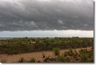
Weather Topic: What are Shelf Clouds?
Home - Education - Cloud Types - Shelf Clouds
 Next Topic: Sleet
A shelf cloud is similar to a wall cloud, but forms at the front
of a storm cloud, instead of at the rear, where wall clouds form.
A shelf cloud is caused by a series of events set into motion by the advancing
storm; first, cool air settles along the ground where precipitation has just fallen.
As the cool air is brought in, the warmer air is displaced, and rises above it,
because it is less dense. When the warmer air reaches the bottom of the storm cloud,
it begins to cool again, and the resulting condensation is a visible shelf cloud.
Next Topic: Sleet
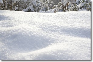
Weather Topic: What is Snow?
Home - Education - Precipitation - Snow
 Next Topic: Stratocumulus Clouds
Snow is precipitation taking the form of ice crystals. Each ice crystal, or snowflake,
has unique characteristics, but all of them grow in a hexagonal structure.
Snowfall can last for sustained periods of time and result in significant buildup
of snow on the ground.
On the earth's surface, snow starts out light and powdery, but as it begins to melt
it tends to become more granular, producing small bits of ice which have the consistency of
sand. After several cycles of melting and freezing, snow can become very dense
and ice-like, commonly known as snow pack.
Next Topic: Stratocumulus Clouds
Current conditions powered by WeatherAPI.com


