Weather Alert in Wyoming
High Wind Watch issued March 9 at 2:02PM MDT until March 15 at 12:00AM MDT by NWS Cheyenne WY
AREAS AFFECTED: North Snowy Range Foothills
DESCRIPTION: * WHAT...West winds 30 to 40 mph with gusts up to 65 mph expected through Monday afternoon. Another period of strong winds gusting up to 65 mph is possible Tuesday afternoon through late Tuesday night. Then, after a break, west winds 30 to 55 mph with gusts up to 85 mph possible Wednesday afternoon through Saturday evening. * WHERE...North Snowy Range Foothills including Arlington and Elk Mountain along Interstate 80. * WHEN...For the High Wind Warning, until 6 PM MDT this evening. For the first High Wind Watch, from Tuesday afternoon through late Tuesday night. For the second High Wind Watch, from Wednesday evening through Saturday evening. * IMPACTS...Mainly to transportation. Strong cross winds will be hazardous to light weight or high profile vehicles, including campers and tractor trailers. * ADDITIONAL DETAILS...This will be a long duration wind event lasting most of the week ahead. Occasional lulls or breaks are possible through this period.
INSTRUCTION: A High Wind Warning means a hazardous high wind event is expected or occurring. Sustained wind speeds of at least 40 MPH or gusts of 58 MPH or stronger can lead to property damage.
Want more detail? Get the Complete 7 Day and Night Detailed Forecast!
Current U.S. National Radar--Current
The Current National Weather Radar is shown below with a UTC Time (subtract 5 hours from UTC to get Eastern Time).

National Weather Forecast--Current
The Current National Weather Forecast and National Weather Map are shown below.

National Weather Forecast for Tomorrow
Tomorrow National Weather Forecast and Tomorrow National Weather Map are show below.

North America Water Vapor (Moisture)
This map shows recent moisture content over North America. Bright and colored areas show high moisture (ie, clouds); brown indicates very little moisture present; black indicates no moisture.

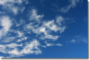
Weather Topic: What are Altostratus Clouds?
Home - Education - Cloud Types - Altostratus Clouds
 Next Topic: Cirrocumulus Clouds
Altostratus clouds form at mid to high-level altitudes
(between 2 and 7 km) and are created by a warm, stable air mass which causes
water vapor
to condense as it rise through the atmosphere. Usually altostratus clouds are
featureless sheets characterized by a uniform color.
In some cases, wind punching through the cloud formation may give it a waved
appearance, called altostratus undulatus. Altostratus clouds
are commonly seen with other cloud formations accompanying them.
Next Topic: Cirrocumulus Clouds
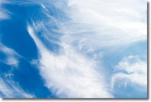
Weather Topic: What are Cirrostratus Clouds?
Home - Education - Cloud Types - Cirrostratus Clouds
 Next Topic: Cirrus Clouds
Cirrostratus clouds are high, thin clouds that form above
20,000 feet and are made mostly of ice crystals. They sometimes look like giant
feathers, horse tails, or curls of hair in the sky.
These clouds are pushed by the jet stream and can move at high speeds reaching
100 mph.
What do they indicate?
They indicate that a precipitation is likely within 24 hours.
Next Topic: Cirrus Clouds
Current conditions powered by WeatherAPI.com


