Weather Alert in Wyoming
High Wind Warning issued March 9 at 2:02PM MDT until March 9 at 6:00PM MDT by NWS Cheyenne WY
AREAS AFFECTED: North Snowy Range Foothills
DESCRIPTION: * WHAT...West winds 30 to 40 mph with gusts up to 65 mph expected through Monday afternoon. Another period of strong winds gusting up to 65 mph is possible Tuesday afternoon through late Tuesday night. Then, after a break, west winds 30 to 55 mph with gusts up to 85 mph possible Wednesday afternoon through Saturday evening. * WHERE...North Snowy Range Foothills including Arlington and Elk Mountain along Interstate 80. * WHEN...For the High Wind Warning, until 6 PM MDT this evening. For the first High Wind Watch, from Tuesday afternoon through late Tuesday night. For the second High Wind Watch, from Wednesday evening through Saturday evening. * IMPACTS...Mainly to transportation. Strong cross winds will be hazardous to light weight or high profile vehicles, including campers and tractor trailers. * ADDITIONAL DETAILS...This will be a long duration wind event lasting most of the week ahead. Occasional lulls or breaks are possible through this period.
INSTRUCTION: A High Wind Warning means a hazardous high wind event is expected or occurring. Sustained wind speeds of at least 40 MPH or gusts of 58 MPH or stronger can lead to property damage.
Want more detail? Get the Complete 7 Day and Night Detailed Forecast!
Current U.S. National Radar--Current
The Current National Weather Radar is shown below with a UTC Time (subtract 5 hours from UTC to get Eastern Time).

National Weather Forecast--Current
The Current National Weather Forecast and National Weather Map are shown below.

National Weather Forecast for Tomorrow
Tomorrow National Weather Forecast and Tomorrow National Weather Map are show below.

North America Water Vapor (Moisture)
This map shows recent moisture content over North America. Bright and colored areas show high moisture (ie, clouds); brown indicates very little moisture present; black indicates no moisture.

Weather Topic: What are Fractus Clouds?
Home - Education - Cloud Types - Fractus Clouds
 Next Topic: Freezing Rain
A fractus cloud (scud) is a fragmented, tattered cloud which has
likely been sheared off of another cloud. They are accessory clouds, meaning they
develop from parent clouds, and are named in a way which describes the original
cloud which contained them.
Fractus clouds which have originated from cumulus clouds are referred to as
cumulus fractus, while fractus clouds which have originated from stratus clouds
are referred to as stratus fractus. Under certain conditions a fractus cloud might
merge with another cloud, or develop into a cumulus cloud, but usually a
fractus cloud seen by itself will dissipate rapidly.
They are often observed on the leading and trailing edges of storm clouds,
and are a display of wind activity.
Next Topic: Freezing Rain
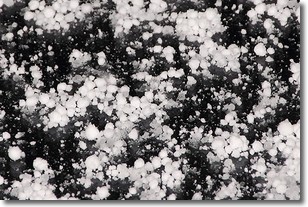
Weather Topic: What is Graupel?
Home - Education - Precipitation - Graupel
 Next Topic: Hail
Graupel is a form of precipitation that is created by atmospheric conditions
which cause supercooled water droplets to contact snow crystals and freeze to
their surface.
Sometimes known as soft hail or snow pellets, graupel is delicate and easily
destroyed by touch. Whereas hail usually falls during severe weather, graupel
doesn't require such conditions to form, and can form in mild precipitation
similar to situations which produce snowfall.
Next Topic: Hail
Current conditions powered by WeatherAPI.com


