Weather Alert in Oregon
Winter Weather Advisory issued February 15 at 11:20AM PST until February 19 at 10:00AM PST by NWS Medford OR
AREAS AFFECTED: Eastern Curry County and Josephine County
DESCRIPTION: ...LOW SNOW LEVELS WITH MULTIPLE ROUNDS OF PRECIPITATION... .A sharp cold front will push through the region Monday night into Tuesday morning with a cold air mass to follow through at least Thursday. Snow levels will quickly lower from around 3000 ft during the day Monday to around 1000-1500 ft late Monday night into the early hours of Tuesday. Multiple waves of precipitation will move through the region while this cold air mass is in place, bringing multiple opportunities for low elevation snow. This will be a long duration event, and after the initial front Monday night, precipitation will become more showery, resulting in periods of spotty and quick accumulations. The values reflected below indicate totals over a 72 hour period from 10pm Monday through 10pm Thursday. Daytime heating will result in snow levels rising to around 2000-2500 ft during the daylight hours, then lower back down during the overnight periods. The best chances for accumulating snow down to valley floors will be during the overnight and early morning hours. * WHAT...For the Winter Weather Advisory below 1500 ft, wet snow expected. Total snow accumulations 2 to 4 inches. For the Winter Storm Warning above 1500 ft, heavy snow expected. Total snow accumulations 4 to 8 inches for the passes north of I-5, and 6 to 12 inches for the southern portions of the Illinois Valley. Up to 2 ft in the Kalmiopsis region. * WHERE...For the Winter Weather Advisory below 1500 ft, this includes the communities of Grants Pass, Wilderville, Merlin, Galice and Agness as well as portins of I-5 and Highway 199. For the Winter Storm Warning above 1500 ft, this includes the communities of Cave Junction, Obrien, Selma and Wolf Creek. This also includes portions of I-5 and Highway 199 and the Sexton Pass, Smith Hill and Stage Pass on I-5, Hayes Hill on Highway 199 and Bear Camp road in the Kalmiopsis Wilderness. * WHEN...From 10 PM Monday to 10 AM PST Thursday. * IMPACTS...Travel may be very difficult to impossible. The hazardous conditions could impact the Tuesday morning and evening commutes. * ADDITIONAL DETAILS...The heaviest snow is expected Monday night into early Tuesday morning. Visit weather.gov/mfr/winter for snow probabilities.
INSTRUCTION: Slow down and use caution while traveling. Call 511 or visit tripcheck.com for road information. If you must travel, keep an extra flashlight, food, and water in your vehicle in case of an emergency. Call 511 or visit tripcheck.com for road information.
Want more detail? Get the Complete 7 Day and Night Detailed Forecast!
Current U.S. National Radar--Current
The Current National Weather Radar is shown below with a UTC Time (subtract 5 hours from UTC to get Eastern Time).

National Weather Forecast--Current
The Current National Weather Forecast and National Weather Map are shown below.

National Weather Forecast for Tomorrow
Tomorrow National Weather Forecast and Tomorrow National Weather Map are show below.

North America Water Vapor (Moisture)
This map shows recent moisture content over North America. Bright and colored areas show high moisture (ie, clouds); brown indicates very little moisture present; black indicates no moisture.

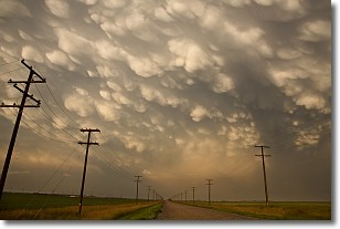
Weather Topic: What are Mammatus Clouds?
Home - Education - Cloud Types - Mammatus Clouds
 Next Topic: Nimbostratus Clouds
A mammatus cloud is a cloud with a unique feature which resembles
a web of pouches hanging along the base of the cloud.
In the United States, mammatus clouds tend to form in the warmer months, commonly
in the Midwest and eastern regions.
While they usually form at the bottom of a cumulonimbis cloud, they can also form
under altostratus, altocumulus, stratocumulus, and cirrus clouds. Mammatus clouds
warn that severe weather is close.
Next Topic: Nimbostratus Clouds
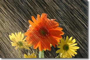
Weather Topic: What is Precipitation?
Home - Education - Precipitation - Precipitation
 Next Topic: Rain
Precipitation can refer to many different forms of water that
may fall from clouds. Precipitation occurs after a cloud has become saturated to
the point where its water particles are more dense than the air below the cloud.
In most cases, precipitation will reach the ground, but it is not uncommon for
precipitation to evaporate before it reaches the earth's surface.
When precipitation evaporates before it contacts the ground it is called Virga.
Graupel, hail, sleet, rain, drizzle, and snow are forms of precipitation, but fog
and mist are not considered precipitation because the water vapor which
constitutes them isn't dense enough to fall to the ground.
Next Topic: Rain
Current conditions powered by WeatherAPI.com


