Weather Alert in Oregon
Winter Storm Warning issued February 15 at 11:20AM PST until February 19 at 10:00AM PST by NWS Medford OR
AREAS AFFECTED: Central Douglas County
DESCRIPTION: ...LOW SNOW LEVELS WITH MULTIPLE ROUNDS OF PRECIPITATION... .A sharp cold front will push through the region Monday night into Tuesday morning with a cold air mass to follow through at least Thursday. Snow levels will quickly lower from around 3000 ft during the day Monday to around 1000-1500 ft late Monday night into the early hours of Tuesday. Multiple waves of precipitation will move through the region while this cold air mass is in place, bringing multiple opportunities for low elevation snow. This will be a long duration event, and after the initial front Monday night, precipitation will become more showery, resulting in periods of spotty and quick accumulations. The values reflected below indicate totals over a 72 hour period from 10pm Monday through 10pm Thursday. Daytime heating will result in snow levels rising to around 2000-2500 ft during the daylight hours, then lower back down during the overnight periods. The best chances for accumulating snow down to valley floors will be during the overnight and early morning hours. * WHAT...For the Winter Weather Advisory below 1500 ft, wet snow expected. Total snow accumulations up to 0.5 to 2 inches, except 4 to 6 inches in the Camas Valley. For the Winter Storm Warning above 1500 ft, heavy snow expected. Total snow accumulations 6 to 10 inches, with 12 to 18 inches expected above 2500 ft. * WHERE...For the Winter Weather Advisory below 1500 ft, this includes the communities of Roseburg, Elkton, Sutherlin, Camas Valley and Canyonville as well as portions of I-5, including Roberts Mountain Pass on I-5 at 1000 ft, and Highways 42 and 130. For the Winter Storm Warning above 1500 ft, this includes the communities of Glendale and Tiller as well as portions of I-5 south of Canyonville and includes and Canyon Creek Pass on I-5 around 2000 ft. * WHEN...From 10 PM Monday to 10 AM PST Thursday. * IMPACTS...Travel may be very difficult to impossible. The hazardous conditions could impact the Tuesday morning and evening commutes. * ADDITIONAL DETAILS...The heaviest snow is expected late Monday night into Tuesday morning. Visit weather.gov/mfr/winter for snow probabilities.
INSTRUCTION: Slow down and use caution while traveling. Call 511 or visit tripcheck.com for road information. If you must travel, keep an extra flashlight, food, and water in your vehicle in case of an emergency. Call 511 or visit tripcheck.com for road information.
Want more detail? Get the Complete 7 Day and Night Detailed Forecast!
Current U.S. National Radar--Current
The Current National Weather Radar is shown below with a UTC Time (subtract 5 hours from UTC to get Eastern Time).

National Weather Forecast--Current
The Current National Weather Forecast and National Weather Map are shown below.

National Weather Forecast for Tomorrow
Tomorrow National Weather Forecast and Tomorrow National Weather Map are show below.

North America Water Vapor (Moisture)
This map shows recent moisture content over North America. Bright and colored areas show high moisture (ie, clouds); brown indicates very little moisture present; black indicates no moisture.

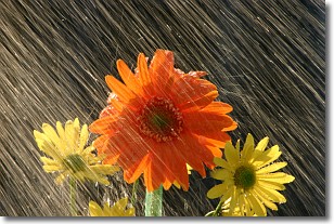
Weather Topic: What is Rain?
Home - Education - Precipitation - Rain
 Next Topic: Shelf Clouds
Precipitation in the form of water droplets is called rain.
Rain generally has a tendency to fall with less intensity over a greater period
of time, and when rainfall is more severe it is usually less sustained.
Rain is the most common form of precipitation and happens with greater frequency
depending on the season and regional influences. Cities have been shown to have
an observable effect on rainfall, due to an effect called the urban heat island.
Compared to upwind, monthly rainfall between twenty and forty miles downwind of
cities is 30% greater.
Next Topic: Shelf Clouds
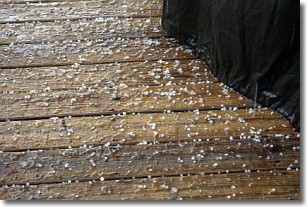
Weather Topic: What is Sleet?
Home - Education - Precipitation - Sleet
 Next Topic: Snow
Sleet is a form of precipitation in which small ice pellets are the primary
components. These ice pellets are smaller and more translucent than hailstones,
and harder than graupel. Sleet is caused by specific atmospheric conditions and
therefore typically doesn't last for extended periods of time.
The condition which leads to sleet formation requires a warmer body of air to be
wedged in between two sub-freezing bodies of air. When snow falls through a warmer
layer of air it melts, and as it falls through the next sub-freezing body of air
it freezes again, forming ice pellets known as sleet. In some cases, water
droplets don't have time to freeze before reaching the surface and the result is
freezing rain.
Next Topic: Snow
Current conditions powered by WeatherAPI.com


