Weather Alert in California
Winter Storm Watch issued February 14 at 12:20PM PST until February 19 at 9:00AM PST by NWS Los Angeles/Oxnard CA
AREAS AFFECTED: Northern Ventura County Mountains; Eastern San Gabriel Mountains
DESCRIPTION: * WHAT...Heavy snow possible. Total snow accumulations of 1 to 4 inches for 3500 to 4500 feet elevation possible, 6 to 12 inches for 4500 to 6000 feet elevation possible, and one to two feet above 6000 feet elevation possible. Wind gusts of 60 to 70 mph through Monday afternoon possible, and as high as 50 mph through Thursday morning possible. * WHERE...Eastern San Gabriel Mountains and Northern Ventura County Mountains. * WHEN...From Monday morning through Thursday morning. * IMPACTS...Roads, and especially bridges and overpasses, will likely become slick and hazardous. Travel could become treacherous. Visibilities may drop below one-quarter mile due to falling and blowing snow. Damaging winds could blow down trees and power lines. * ADDITIONAL DETAILS...There will be a break in the snowfall for Tuesday into Tuesday night, before heavy snow returns by Wednesday. However, blowing and drifting snow producing significant visibility restrictions will continue above 6000 feet elevation, even during the break in snowfall.
INSTRUCTION: Monitor the latest forecasts for updates on this situation. If travel is absolutely necessary, drive with extreme caution and be prepared for sudden changes in visibility. Leave plenty of room between you and the motorist ahead of you, and allow extra time to reach your destination. Avoid sudden braking or acceleration, and be especially cautious on hills or when making turns. Make sure your car is winterized and in good working order. Damaging winds could blow down trees and power lines. Travel could be difficult, especially for high profile vehicles.
Want more detail? Get the Complete 7 Day and Night Detailed Forecast!
Current U.S. National Radar--Current
The Current National Weather Radar is shown below with a UTC Time (subtract 5 hours from UTC to get Eastern Time).

National Weather Forecast--Current
The Current National Weather Forecast and National Weather Map are shown below.

National Weather Forecast for Tomorrow
Tomorrow National Weather Forecast and Tomorrow National Weather Map are show below.

North America Water Vapor (Moisture)
This map shows recent moisture content over North America. Bright and colored areas show high moisture (ie, clouds); brown indicates very little moisture present; black indicates no moisture.

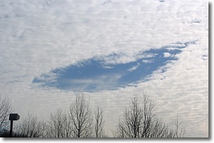
Weather Topic: What are Hole Punch Clouds?
Home - Education - Cloud Types - Hole Punch Clouds
 Next Topic: Mammatus Clouds
A hole punch cloud is an unusual occurrence when a disk-shaped
hole appears in a cirrostratus, cirrocumulus, or altocumulus cloud.
When part of the cloud forms ice crystals, water droplets in the surrounding area
of the cloud evaporate. The effect of this process produces a large elliptical
gap in the cloud. The hole punch cloud formation is rare, but it is not specific
to any geographic area.
Other names which have been used to describe this phenomena include fallstreak hole,
skypunch, and cloud hole.
Next Topic: Mammatus Clouds
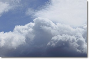
Weather Topic: What are Nimbostratus Clouds?
Home - Education - Cloud Types - Nimbostratus Clouds
 Next Topic: Precipitation
A nimbostratus cloud is similar to a stratus cloud in its formless,
smooth appearance. However, a nimbostratus cloud is darker than a stratus cloud,
because it is thicker.
Unlike a stratus cloud, a nimbostratus cloud typically brings with it the threat
of moderate to heavy precipitation. In some cases, the precipitation may evaporate
before reaching the ground, a phenomenon known as virga.
Next Topic: Precipitation
Current conditions powered by WeatherAPI.com


