Weather Alert in California
Winter Storm Watch issued February 14 at 12:20PM PST until February 19 at 9:00AM PST by NWS Los Angeles/Oxnard CA
AREAS AFFECTED: Northern Ventura County Mountains; Eastern San Gabriel Mountains
DESCRIPTION: * WHAT...Heavy snow possible. Total snow accumulations of 1 to 4 inches for 3500 to 4500 feet elevation possible, 6 to 12 inches for 4500 to 6000 feet elevation possible, and one to two feet above 6000 feet elevation possible. Wind gusts of 60 to 70 mph through Monday afternoon possible, and as high as 50 mph through Thursday morning possible. * WHERE...Eastern San Gabriel Mountains and Northern Ventura County Mountains. * WHEN...From Monday morning through Thursday morning. * IMPACTS...Roads, and especially bridges and overpasses, will likely become slick and hazardous. Travel could become treacherous. Visibilities may drop below one-quarter mile due to falling and blowing snow. Damaging winds could blow down trees and power lines. * ADDITIONAL DETAILS...There will be a break in the snowfall for Tuesday into Tuesday night, before heavy snow returns by Wednesday. However, blowing and drifting snow producing significant visibility restrictions will continue above 6000 feet elevation, even during the break in snowfall.
INSTRUCTION: Monitor the latest forecasts for updates on this situation. If travel is absolutely necessary, drive with extreme caution and be prepared for sudden changes in visibility. Leave plenty of room between you and the motorist ahead of you, and allow extra time to reach your destination. Avoid sudden braking or acceleration, and be especially cautious on hills or when making turns. Make sure your car is winterized and in good working order. Damaging winds could blow down trees and power lines. Travel could be difficult, especially for high profile vehicles.
Want more detail? Get the Complete 7 Day and Night Detailed Forecast!
Current U.S. National Radar--Current
The Current National Weather Radar is shown below with a UTC Time (subtract 5 hours from UTC to get Eastern Time).

National Weather Forecast--Current
The Current National Weather Forecast and National Weather Map are shown below.

National Weather Forecast for Tomorrow
Tomorrow National Weather Forecast and Tomorrow National Weather Map are show below.

North America Water Vapor (Moisture)
This map shows recent moisture content over North America. Bright and colored areas show high moisture (ie, clouds); brown indicates very little moisture present; black indicates no moisture.

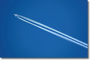
Weather Topic: What are Contrails?
Home - Education - Cloud Types - Contrails
 Next Topic: Cumulonimbus Clouds
A contrail is an artificial cloud, created by the passing of an
aircraft.
Contrails form because water vapor in the exhaust of aircraft engines is suspended
in the air under certain temperatures and humidity conditions. These contrails
are called exhaust contrails.
Another type of contrail can form due to a temporary reduction in air pressure
moving over the plane's surface, causing condensation.
These are called aerodynamic contrails.
When you can see your breath on a cold day, it is also because of condensation.
The reason contrails last longer than the condensation from your breath is
because the water in contrails freezes into ice particles.
Next Topic: Cumulonimbus Clouds
Weather Topic: What are Cumulus Clouds?
Home - Education - Cloud Types - Cumulus Clouds
 Next Topic: Drizzle
Cumulus clouds are fluffy and textured with rounded tops, and
may have flat bottoms. The border of a cumulus cloud
is clearly defined, and can have the appearance of cotton or cauliflower.
Cumulus clouds form at low altitudes (rarely above 2 km) but can grow very tall,
becoming cumulus congestus and possibly the even taller cumulonimbus clouds.
When cumulus clouds become taller, they have a greater chance of producing precipitation.
Next Topic: Drizzle
Current conditions powered by WeatherAPI.com


