Weather Alert in West Virginia
Special Weather Statement issued February 8 at 8:04PM EST by NWS Charleston WV
AREAS AFFECTED: Northwest Pocahontas; Southeast Pocahontas; Northwest Randolph; Southeast Randolph
DESCRIPTION: High pressure with clear, calm conditions atop the snowpack provide the perfect mid-winter setup for a frigid night and early Monday morning. Temperatures will bottom out in the single digits, single digits below zero in the normally colder low spots away from rivers, even isolated double digit lows below zero in the normally coldest sheltered mountain valleys, particularly for northern portions of Randolph and Pocahontas counties. Even with little or no wind, these low temperatures can lead to frostbite in as little as 30 minutes on exposed skin, as well as hypothermia. Bundle up if you must venture outside anytime tonight through early Monday morning, including the morning commute and bus run. If traveling, be prepared in case of a breakdown.
INSTRUCTION: N/A
Want more detail? Get the Complete 7 Day and Night Detailed Forecast!
Current U.S. National Radar--Current
The Current National Weather Radar is shown below with a UTC Time (subtract 5 hours from UTC to get Eastern Time).

National Weather Forecast--Current
The Current National Weather Forecast and National Weather Map are shown below.

National Weather Forecast for Tomorrow
Tomorrow National Weather Forecast and Tomorrow National Weather Map are show below.

North America Water Vapor (Moisture)
This map shows recent moisture content over North America. Bright and colored areas show high moisture (ie, clouds); brown indicates very little moisture present; black indicates no moisture.

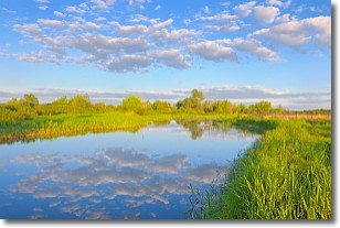
Weather Topic: What are Stratocumulus Clouds?
Home - Education - Cloud Types - Stratocumulus Clouds
 Next Topic: Stratus Clouds
Stratocumulus clouds are similar to altocumulus clouds in their
fluffy appearance, but have a slightly darker shade due to their additional mass.
A good way to distinguish the two cloud types is to hold your hand out and measure
the size of an individual cloud; if it is the size of your thumb it is generally
an altocumulus cloud, if it is the size of your hand it is generally a
stratocumulus cloud.
It is uncommon for stratocumulus clouds to produce precipitation, but if they do
it is usually a light rain or snow.
Next Topic: Stratus Clouds
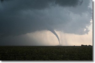
Weather Topic: What are Wall Clouds?
Home - Education - Cloud Types - Wall Clouds
 Next Topic: Altocumulus Clouds
A wall cloud forms underneath the base of a cumulonimbus cloud,
and can be a hotbed for deadly tornadoes.
Wall clouds are formed by air flowing into the cumulonimbus clouds, which can
result in the wall cloud descending from the base of the cumulonimbus cloud, or
rising fractus clouds which join to the base of the storm cloud as the wall cloud
takes shape.
Wall clouds can be very large, and in the Northern Hemisphere they generally
form at the southern edge of cumulonimbus clouds.
Next Topic: Altocumulus Clouds
Current conditions powered by WeatherAPI.com


