Weather Alert in Colorado
Flood Watch issued August 26 at 2:57AM MDT until August 27 at 12:00AM MDT by NWS Grand Junction CO
AREAS AFFECTED: Roan and Tavaputs Plateaus; Grand Valley; Debeque to Silt Corridor; Central Colorado River Basin; Grand and Battlement Mesas; Gore and Elk Mountains/Central Mountain Valleys; Central Gunnison and Uncompahgre River Basin; West Elk and Sawatch Mountains; Flat Tops; Upper Gunnison River Valley; Uncompahgre Plateau/Dallas Divide; Northwestern San Juan Mountains; Southwest San Juan Mountains; Paradox Valley/Lower Dolores River; Four Corners/Upper Dolores River; Animas River Basin; San Juan River Basin; Southeast Utah; La Sal and Abajo Mountains; Canyonlands/Natural Bridges
DESCRIPTION: * WHAT...Flash flooding caused by excessive rainfall continues to be possible. * WHERE...Portions of Colorado, including the following areas, along the I-70 corridor, Flat Tops, Four Corners, Central Mountain Valleys, Grand Valley, Grand and Battlement Mesas, Western San Juan Mountains, Uncompahgre Plateau and Dallas Divide, Upper Gunnison River Valley and West Elk and Sawatch Mountains, and portions of southeast Utah, including the following areas, Canyonlands/Natural Bridges and the La Sal and Abajo Mountains. This also includes the Elk/Lee Complex, Turner Gulch, Deer Creek, Stoner Mesa, and South Rim burn scars. * WHEN...From 6 AM MDT this morning through this evening. * IMPACTS...Excessive runoff may result in flooding of rivers, creeks, streams, and other low-lying and flood-prone locations. Area creeks and streams are running high and could flood with more heavy rain. Heavy rain over burn scars may lead to debris flows. * ADDITIONAL DETAILS... - http://www.weather.gov/safety/flood
INSTRUCTION: You should monitor later forecasts and be prepared to take action should Flash Flood Warnings be issued.
Want more detail? Get the Complete 7 Day and Night Detailed Forecast!
Current U.S. National Radar--Current
The Current National Weather Radar is shown below with a UTC Time (subtract 5 hours from UTC to get Eastern Time).

National Weather Forecast--Current
The Current National Weather Forecast and National Weather Map are shown below.

National Weather Forecast for Tomorrow
Tomorrow National Weather Forecast and Tomorrow National Weather Map are show below.

North America Water Vapor (Moisture)
This map shows recent moisture content over North America. Bright and colored areas show high moisture (ie, clouds); brown indicates very little moisture present; black indicates no moisture.

Weather Topic: What is Graupel?
Home - Education - Precipitation - Graupel
 Next Topic: Hail
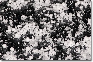
Graupel is a form of precipitation that is created by atmospheric conditions
which cause supercooled water droplets to contact snow crystals and freeze to
their surface.
Sometimes known as soft hail or snow pellets, graupel is delicate and easily
destroyed by touch. Whereas hail usually falls during severe weather, graupel
doesn't require such conditions to form, and can form in mild precipitation
similar to situations which produce snowfall.
Next Topic: Hail
Weather Topic: What are Hole Punch Clouds?
Home - Education - Cloud Types - Hole Punch Clouds
 Next Topic: Mammatus Clouds
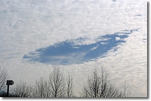
A hole punch cloud is an unusual occurrence when a disk-shaped
hole appears in a cirrostratus, cirrocumulus, or altocumulus cloud.
When part of the cloud forms ice crystals, water droplets in the surrounding area
of the cloud evaporate. The effect of this process produces a large elliptical
gap in the cloud. The hole punch cloud formation is rare, but it is not specific
to any geographic area.
Other names which have been used to describe this phenomena include fallstreak hole,
skypunch, and cloud hole.
Next Topic: Mammatus Clouds
Current conditions powered by WeatherAPI.com


