Weather Alert in Nebraska
Red Flag Warning issued February 9 at 1:27AM CST until February 9 at 6:00PM CST by NWS North Platte NE
AREAS AFFECTED: Eastern Panhandle/Crescent Lake NWR; Sandhills/Valentine NWR/Nebraska National Forest
DESCRIPTION: ...CRITICAL FIRE WEATHER CONDITIONS THROUGH THIS AFTERNOON... .The combination of low relative humidity and gusty winds through this afternoon, will lead to critical fire weather conditions across the Sandhills. Westerly winds of 20 to 30 mph with gusts to 40 mph are expected across the western Sandhills, with gusts of 25 to 30 mph further east across the Sandhills. Winds will turn northwest late afternoon. The National Weather Service in North Platte has issued a Red Flag Warning for gusty west winds, warm temperatures and low relative humidity, which is in effect from 9 AM CST /8 AM MST/ to 6 PM CST /5 PM MST/ this evening. * AFFECTED AREA...Fire Weather Zone 204 Eastern Panhandle/Crescent Lake NWR and Fire Weather Zone 206 Sandhills/Valentine NWR/Nebraska National Forest. * TIMING...From mid-morning Monday through the afternoon hours. * WINDS...West 20 to 30 mph with gusts up to 40 mph, becoming northwest late in the afternoon. * RELATIVE HUMIDITY...As low as 14 percent. * TEMPERATURES...Up to 75. * IMPACTS...Any fire starts will have the potential for quick growth and rapid spread and may be difficult to control.
INSTRUCTION: A Red Flag Warning means that critical fire weather conditions are either occurring now, or will shortly. A combination of strong winds, low relative humidity, and warm temperatures can contribute to extreme fire behavior.
Want more detail? Get the Complete 7 Day and Night Detailed Forecast!
Current U.S. National Radar--Current
The Current National Weather Radar is shown below with a UTC Time (subtract 5 hours from UTC to get Eastern Time).

National Weather Forecast--Current
The Current National Weather Forecast and National Weather Map are shown below.

National Weather Forecast for Tomorrow
Tomorrow National Weather Forecast and Tomorrow National Weather Map are show below.

North America Water Vapor (Moisture)
This map shows recent moisture content over North America. Bright and colored areas show high moisture (ie, clouds); brown indicates very little moisture present; black indicates no moisture.

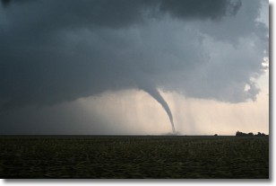
Weather Topic: What are Wall Clouds?
Home - Education - Cloud Types - Wall Clouds
 Next Topic: Altocumulus Clouds
A wall cloud forms underneath the base of a cumulonimbus cloud,
and can be a hotbed for deadly tornadoes.
Wall clouds are formed by air flowing into the cumulonimbus clouds, which can
result in the wall cloud descending from the base of the cumulonimbus cloud, or
rising fractus clouds which join to the base of the storm cloud as the wall cloud
takes shape.
Wall clouds can be very large, and in the Northern Hemisphere they generally
form at the southern edge of cumulonimbus clouds.
Next Topic: Altocumulus Clouds
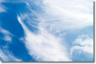
Weather Topic: What are Altostratus Clouds?
Home - Education - Cloud Types - Altostratus Clouds
 Next Topic: Cirrocumulus Clouds
Altostratus clouds form at mid to high-level altitudes
(between 2 and 7 km) and are created by a warm, stable air mass which causes
water vapor
to condense as it rise through the atmosphere. Usually altostratus clouds are
featureless sheets characterized by a uniform color.
In some cases, wind punching through the cloud formation may give it a waved
appearance, called altostratus undulatus. Altostratus clouds
are commonly seen with other cloud formations accompanying them.
Next Topic: Cirrocumulus Clouds
Current conditions powered by WeatherAPI.com


