Weather Alert in Oregon
Flash Flood Watch issued September 10 at 12:42PM PDT until September 10 at 11:00PM PDT by NWS Pendleton OR
AREAS AFFECTED: East Slopes of the Oregon Cascades; Central Oregon
DESCRIPTION: * WHAT...Flash flooding and debris flows caused by excessive rainfall are possible over recent burn scars. * WHERE...A portion of central Oregon, including the following areas, Central Oregon and East Slopes of the Oregon Cascades. * WHEN...Until 11 PM PDT this evening. * IMPACTS...Heavy rainfall of up to an inch over recent burn scars is expected up to and during the period of the watch. Residents near recent burn scars should prepare for potential flooding impacts. Be sure to stay up to date with information from local authorities. Heavy rainfall could trigger flash flooding of low-lying areas, urbanized street flooding, and debris flows in and near recent wildfire burn scars. * ADDITIONAL DETAILS... - National Weather Service Meteorologists are forecasting heavy rainfall over the burn scar, which may lead to flash flooding and debris flows. - http://www.weather.gov/safety/flood
INSTRUCTION: You should monitor later forecasts and be prepared to take action should Flash Flood Warnings be issued.
Want more detail? Get the Complete 7 Day and Night Detailed Forecast!
Current U.S. National Radar--Current
The Current National Weather Radar is shown below with a UTC Time (subtract 5 hours from UTC to get Eastern Time).

National Weather Forecast--Current
The Current National Weather Forecast and National Weather Map are shown below.

National Weather Forecast for Tomorrow
Tomorrow National Weather Forecast and Tomorrow National Weather Map are show below.

North America Water Vapor (Moisture)
This map shows recent moisture content over North America. Bright and colored areas show high moisture (ie, clouds); brown indicates very little moisture present; black indicates no moisture.

Weather Topic: What is Freezing Rain?
Home - Education - Precipitation - Freezing Rain
 Next Topic: Graupel
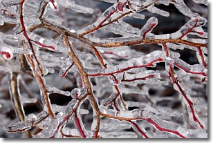
Freezing rain is a condition where precipitation which has fallen in the form of
water droplets reaches temperatures which are below freezing and freezes upon
coming into contact
with surface objects. The result of this precipitation is a glaze of ice which
can be damaging to plants and man-made structures. A severe onset of freezing
rain which results in a very thick glaze of ice is known as an ice storm.
Next Topic: Graupel
Weather Topic: What is Hail?
Home - Education - Precipitation - Hail
 Next Topic: Hole Punch Clouds
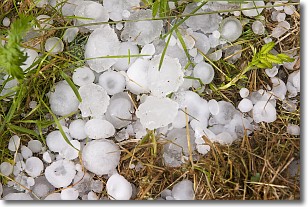
Hail is a form of precipitation which is recognized by large solid balls or
clumps of ice. Hail is created by thunderstorm clouds with strong updrafts of wind.
As the hailstones remain in the updraft, ice is deposited onto them until their
weight becomes heavy enough for them to fall to the earth's surface.
Hail storms can cause significant damage to crops, aircrafts, and man-made structures,
despite the fact that the duration is usually less than ten minutes.
Next Topic: Hole Punch Clouds
Current conditions powered by WeatherAPI.com


