Weather Alert in Alaska
Winter Weather Advisory issued August 26 at 10:01PM AKDT until August 28 at 10:00PM AKDT by NWS Fairbanks AK
AREAS AFFECTED: Central Beaufort Sea Coast
DESCRIPTION: * WHAT...Ice accumulations up to 0.05" possible. * WHERE...Central Arctic Plains, Central Beaufort Sea Coast, and Central Brooks Range. * WHEN...Until 10 PM AKDT Thursday. * IMPACTS...Plan on slippery road conditions. Any accumulating snow and freezing rain could create difficult travel conditions. * ADDITIONAL DETAILS...Though uncertainty remains substantial with the incoming storm system, confidence is increasing in light ice accumulations from one, potentially two periods of light freezing rain/freezing drizzle. The first would be Tuesday Night into Wednesday. During this time, precip types are more uncertain as temperatures are expected to hover within a couple degrees of the freezing mark. A second round of light freezing rain appears increasingly likely Thursday into Thursday night. The greatest ice accumulations will be for the Dalton Highway south of Prudhoe Bay, though hazardous driving conditions from icy road conditions will be possible all the way to the northern extent of the highway, especially by Thursday afternoon/evening.
INSTRUCTION: Slow down and use caution while traveling. The latest road conditions for the state you are calling from can be obtained by calling 5 1 1.
Want more detail? Get the Complete 7 Day and Night Detailed Forecast!
Current U.S. National Radar--Current
The Current National Weather Radar is shown below with a UTC Time (subtract 5 hours from UTC to get Eastern Time).

National Weather Forecast--Current
The Current National Weather Forecast and National Weather Map are shown below.

National Weather Forecast for Tomorrow
Tomorrow National Weather Forecast and Tomorrow National Weather Map are show below.

North America Water Vapor (Moisture)
This map shows recent moisture content over North America. Bright and colored areas show high moisture (ie, clouds); brown indicates very little moisture present; black indicates no moisture.

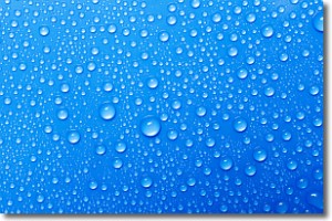
Weather Topic: What is Condensation?
Home - Education - Precipitation - Condensation
 Next Topic: Contrails
Condensation is the process which creates clouds, and therefore
it is a crucial process in the water cycle.
Condensation is the change of matter from a state of gas into a state of liquid,
and it happens because water molecules release heat into the atmosphere and
become organized into a more closely packed structure, what we might see as
water droplets.
Water is always present in the air around us as a vapor, but it's too small for
us to see. When water undergoes the process of condensation it becomes organized
into visible water droplets. You've probably seen condensation happen before on the
surface of a cold drink!
Next Topic: Contrails
Weather Topic: What are Cumulonimbus Clouds?
Home - Education - Cloud Types - Cumulonimbus Clouds
 Next Topic: Cumulus Clouds
The final form taken by a growing cumulus cloud is the
cumulonimbus cloud, which is very tall and dense.
The tower of a cumulonimbus cloud can soar 23 km into the atmosphere, although
most commonly they stop growing at an altitude of 6 km.
Even small cumulonimbus clouds appear very large in comparison to other cloud types.
They can signal the approach of stormy weather, such as thunderstorms or blizzards.
Next Topic: Cumulus Clouds
Current conditions powered by WeatherAPI.com


