Weather Alerts for Washington
1. Air Quality Alert for: Grant, WA; Lincoln, WA; Spokane, WA; Stevens, WA
2. Air Quality Alert for: Grant, WA; Lincoln, WA; Stevens, WA
3. Air Quality Alert for: Kittitas, WA; Yakima, WA
4. Extreme Heat Warning for: Moses Lake Area; Wenatchee Area; Okanogan Valley
5. Heat Advisory for: Foothills and Valleys of the North Cascades; Foothills and Valleys of Snohomish and Northern King Counties; Foothills and Valleys of Central King County; Foothills and Valleys of Pierce and Southern King Counties; Foothills and Valleys of Thurston and Lewis Counties
6. Heat Advisory for: Lower Slopes of the Eastern Washington Cascades Crest
7. Heat Advisory for: Northeast Blue Mountains; Western Chelan County
8. Red Flag Warning for: East Washington Central Cascades
9. Red Flag Warning for: Okanogan Highlands & Kettle Mountains; Selkirk Mountains of Northeast Washington; Foothills of Northeast Washington; Colville Reservation
10. Red Flag Warning for: Southern Gifford Pinchot National Forest; Mt. Adams Ranger District of the Gifford-Pinchot National Forest
11. Red Flag Warning for: West Slopes of the North Cascades Generally above 1500 Feet; West Slopes of the Central Cascades Generally above 1500 Feet
Want more detail? Get the Complete 7 Day and Night Detailed Forecast!
Current U.S. National Radar--Current
The Current National Weather Radar is shown below with a UTC Time (subtract 5 hours from UTC to get Eastern Time).

National Weather Forecast--Current
The Current National Weather Forecast and National Weather Map are shown below.

National Weather Forecast for Tomorrow
Tomorrow National Weather Forecast and Tomorrow National Weather Map are show below.

North America Water Vapor (Moisture)
This map shows recent moisture content over North America. Bright and colored areas show high moisture (ie, clouds); brown indicates very little moisture present; black indicates no moisture.

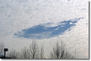
Weather Topic: What are Hole Punch Clouds?
Home - Education - Cloud Types - Hole Punch Clouds
 Next Topic: Mammatus Clouds
A hole punch cloud is an unusual occurrence when a disk-shaped
hole appears in a cirrostratus, cirrocumulus, or altocumulus cloud.
When part of the cloud forms ice crystals, water droplets in the surrounding area
of the cloud evaporate. The effect of this process produces a large elliptical
gap in the cloud. The hole punch cloud formation is rare, but it is not specific
to any geographic area.
Other names which have been used to describe this phenomena include fallstreak hole,
skypunch, and cloud hole.
Next Topic: Mammatus Clouds
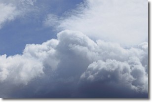
Weather Topic: What are Nimbostratus Clouds?
Home - Education - Cloud Types - Nimbostratus Clouds
 Next Topic: Precipitation
A nimbostratus cloud is similar to a stratus cloud in its formless,
smooth appearance. However, a nimbostratus cloud is darker than a stratus cloud,
because it is thicker.
Unlike a stratus cloud, a nimbostratus cloud typically brings with it the threat
of moderate to heavy precipitation. In some cases, the precipitation may evaporate
before reaching the ground, a phenomenon known as virga.
Next Topic: Precipitation
Current conditions powered by WeatherAPI.com


