Weather Alerts for Wyoming
1. High Wind Warning for: Absaroka Mountains
2. High Wind Warning for: Central Laramie County
3. High Wind Warning for: Central Laramie Range and Southwest Platte County
4. High Wind Warning for: Cody Foothills
5. High Wind Warning for: East Platte County
6. High Wind Warning for: Ferris/Seminoe/Shirley Mountains; Shirley Basin; Central Carbon County
7. High Wind Warning for: Laramie Valley
8. High Wind Warning for: North Snowy Range Foothills
9. High Wind Warning for: Northeast Johnson County
10. High Wind Warning for: Sheridan Foothills
11. High Wind Warning for: South Laramie Range; South Laramie Range Foothills
12. High Wind Warning for: Wind River Mountains East; Upper Wind River Basin
13. High Wind Watch for: Goshen County; East Laramie County
14. High Wind Watch for: Green Mountains and Rattlesnake Range; Natrona County Lower Elevations
15. High Wind Watch for: South Lincoln County; Rock Springs and Green River; Flaming Gorge; East Sweetwater County
16. High Wind Watch for: Wind River Basin
17. High Wind Watch for: Wind River Mountains East; Upper Wind River Basin
18. Winter Storm Warning for: Absaroka Mountains
19. Winter Storm Warning for: Teton and Gros Ventre Mountains; Salt River and Wyoming Ranges
20. Winter Storm Warning for: Wind River Mountains West
21. Winter Storm Warning for: Yellowstone National Park
22. Winter Weather Advisory for: Bighorn Mountains West; Bighorn Mountains Southeast
23. Winter Weather Advisory for: Jackson Hole
24. Winter Weather Advisory for: Sierra Madre Range; Snowy Range
Want more detail? Get the Complete 7 Day and Night Detailed Forecast!
Current U.S. National Radar--Current
The Current National Weather Radar is shown below with a UTC Time (subtract 5 hours from UTC to get Eastern Time).

National Weather Forecast--Current
The Current National Weather Forecast and National Weather Map are shown below.

National Weather Forecast for Tomorrow
Tomorrow National Weather Forecast and Tomorrow National Weather Map are show below.

North America Water Vapor (Moisture)
This map shows recent moisture content over North America. Bright and colored areas show high moisture (ie, clouds); brown indicates very little moisture present; black indicates no moisture.

Weather Topic: What are Altostratus Clouds?
Home - Education - Cloud Types - Altostratus Clouds
 Next Topic: Cirrocumulus Clouds
Altostratus clouds form at mid to high-level altitudes
(between 2 and 7 km) and are created by a warm, stable air mass which causes
water vapor
to condense as it rise through the atmosphere. Usually altostratus clouds are
featureless sheets characterized by a uniform color.
In some cases, wind punching through the cloud formation may give it a waved
appearance, called altostratus undulatus. Altostratus clouds
are commonly seen with other cloud formations accompanying them.
Next Topic: Cirrocumulus Clouds
Weather Topic: What are Cirrostratus Clouds?
Home - Education - Cloud Types - Cirrostratus Clouds
 Next Topic: Cirrus Clouds
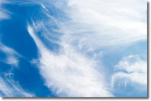
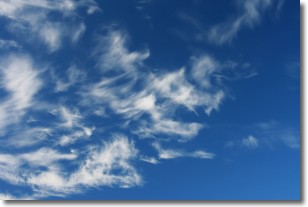
Cirrostratus clouds are high, thin clouds that form above
20,000 feet and are made mostly of ice crystals. They sometimes look like giant
feathers, horse tails, or curls of hair in the sky.
These clouds are pushed by the jet stream and can move at high speeds reaching
100 mph.
What do they indicate?
They indicate that a precipitation is likely within 24 hours.
Next Topic: Cirrus Clouds
Current conditions powered by WeatherAPI.com


